
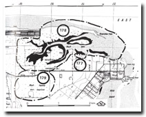
178. Rhyll Inlet (The Nits)
|
This information has been developed from one or more of these publications:
|
Location: | Rhyll – 525417 to 490420. This large area includes all of Rhyll Inlet and the Conservation Hill Reserve. It extends from the eastern end of Settlement Road to the cliffs on the southern side of the inlet north of Rhyll. | 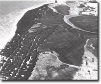 Mangrove and saltmarsh at Rhyll Inlet. Recurving spit complex (A) and relict spits and beach ridges (B). Arrows indicate bluffs on southern side, Site 178. |
| Access: | Silver Leaves Avenue or Settlement Road (Cowes) and coastal walk from the yacht Club building at Rhyll. | |
| Ownership: | Crown land and small area of private land. | |
| Geology/Geomorphology: | Rhyll inlet is a major tidal inlet largely enclosed on the northern side by a series of long sand spits that extend for almost 5 km eastward from Erehwon Point. Three principal stages of spit formation are evident (Jenkin 1962, Walker 1973) and are marked by several broad sandy ridges and intervening swales that trend east to south-east from Cowes. Smaller offset ridges were described by Marsden and Mallett (1975) as equivalent to the subtidal and intertidal sand wave bedforms that are forming at the present times on the Cowes Bank. The active outermost spit terminates as a complex of recurves at Observation Point and there is an extensive intertidal extension of this sand body to the east of the point. The south-eastern margin of the entrance to Rhyll Swamp is a cliffed coastline north of Rhyll that becomes a line of coastal bluffs to the west where it is sheltered by a mangrove and saltmarsh fringe. Rock platforms extend at the base of the cliffs and bluffs and in places the platform is covered by rounded cobbles derived from disintegration of basalt corestones. Saltmarsh deposits cover the platform in the sheltered sectors of the inlet. The marsh-covered platforms and rounded gravels that lie above high water mark are possible indicators of a higher Holocene sea level. | |
| Significance: | State. This is a major tidal inlet as distinct from an estuary as there is negligible fresh water inflow from streams. There is a complex array of active and relict geomorphological features and the site is particularly important for the indications of higher Holocene sea level displayed. It is a major site for the study of spit evolution and dynamics and of nearshore and tidal processes. | |
| Management: | Class 1. Minimum disturbance to the area is required to allow the study of the features described above to be undertaken. Many of the relict spit and sand wave forms occur on private land and have been obscured by buildings. It would be necessary to prohibit similar land disturbance on areas of significance in the western part of the site, particularly adjacent to the end of Settlement Road. The use of the south-west of the site as a rubbish tip should be discontinued. | |
| References: | Jenkin, J.J. (1962). The geology and hydrogeology of the Westernport area. Dept. of Mines Vict. Underground Water Investgation Report No. 5. Walker, G. McK. M.(1973). The Cowes Rhyll area, Phillip Island: a study of recent sediments in a barrier lagoon complex. B.Sc. thesis, Geol. Dept., Univ. of Melb. Barnes, L. (1976). The physiography and evolution of Observation Point and Rhyll Inlet. B.Sc. (Hons) thesis (unpub.) Dept. of Geog., University of Melb. Marsden, M.A.H. & Mallett, C.W. (1975). Quaternary evolution, morphology and sediment distribution, Westernport Bay, Victoria. Proc. Roy. Soc. Vict. Vol. 87 (1) 107-137. | |
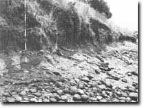 Shore platforms and cliff base revealing cobble layer that may be "raised" beach deposit, Site 178. | 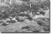 Detail of the cobble and gravel deposit, Rhyll Inlet, Site 178 |

© State of Victoria (Agriculture Victoria) 1996 - .

This work, Victorian Resources Online, is licensed under a Creative Commons Attribution 4.0 licence. You are free to re-use the work under that licence, on the condition that you credit the State of Victoria (Agriculture Victoria) as author, indicate if changes were made and comply with the other licence terms.
The licence does not apply to ‘branding’ or some ‘images or photographs’ that may be owned by third parties. We ask you to seek prior approval to use images using the VRO feedback form. Access to higher quality images can also be provided on request.
This page was last updated on .