
191. Native Dog Creek to Thorny Beach
|
This information has been developed from one or more of these publications:
|
Location: | Pyramid Rock – 431252 to 413354. Coastal cliffs and dunes extending east from Berry Beach Road car park. The site includes Wild Dog Bluff, Helens Head, Hutchison Beach and Thorny Beach. | 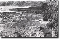 Shore platform swept clear of rock debris except for recent rock fall, Wild Dog Bluff, Site 191 |
Access: | Berry Beach Road is the only public access road. The coast and cliff-top walk presents some hazards due to steep and unstable terrain and strong wave action. | |
Ownership: | Crown land and some private land. | |
Geology/Geomorphology: | The site includes the highest basalt cliffs and the largest boulder beach materials that occur on Phillip Island. At Helens Head where the cliffs rise over 50 m, at least 15 volcanic sequences comprising columnar jointed basalts and tuff and agglomerate beds can be distinguished. The uppermost beds are of massive lava flows with a vertical cliff face section 10 m to 15 m high. The shore platforms are distinctly stepped in profile with several abrupt changes in level. The small bay east of Helens Head contains a very steep boulder beach with several berms. Because of the exposure to wave action, the platforms at Wild Dog Bluff are swept clear of rock debris except where large boulders accumulate as a result of recent cliff collapse. There are several dykes, the one immediately east of Wild Dog Bluff is the largest known on Phillip Island. It is over 1 m wide and stands as a wall over 2 m high across the shore platform. The bays at Hutchison Beach and Thorny Beach are sandy and hummocky dunes have developed at Thorny Beach and ascended the bluff behind this. They are incised by runoff from a small spring and it is surprising that given the width of the beach and the strength of onshore winds the sands have not blocked this stream. The lack of more extensive transgressive dune development can only be attributed to paucity of nearshore sand supplies. | |
Significance: | The plateau edge above the cliffs is broken by a succession of amphitheatre-shaped depressions that probably develop by soil cracking and slumping where springs emerge. The process may be assisted by deflation from the strong onshore winds. Wild Dog Creek at the eastern end of the site is the major stream on Phillip Island and has cut a gorge in its lower sector. Despite the small flow in the creek the gorge is accordant in that the mouth is cut down to sea level. | |
Management: | National. This is a coast of extraordinary character as well as one of high scientific significance. The cliffs and platforms display one of the best horizontal and vertical exposure of Early Tertiary volcanic sequences known in Australia. Associated features of significance include abundant zeolites and the several large dykes. The proximity of cliffs, bluffs, shore platforms, beaches of varied composition and the question of the sparse development of coastal dunes make this a coast of outstanding significance for geomorphological studies. | |
References: | Class 1. No residential or recreational developments should be permitted in the area of the site and should be prohibited in a zone extending for several hundred metres inland from the site boundary. No coastal roadway should be constructed and quarrying or other construction and engineering activities should be excluded from the site. A well planned and graded public footpath along the cliff tops with spur tracks to the beaches and platforms at selected localities would not degrade the important scientific features. | |
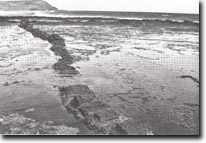 Dyke intruding basalts and crossing shore platform, Berry Reef, Site 191. |

© State of Victoria (Agriculture Victoria) 1996 - .

This work, Victorian Resources Online, is licensed under a Creative Commons Attribution 4.0 licence. You are free to re-use the work under that licence, on the condition that you credit the State of Victoria (Agriculture Victoria) as author, indicate if changes were made and comply with the other licence terms.
The licence does not apply to ‘branding’ or some ‘images or photographs’ that may be owned by third parties. We ask you to seek prior approval to use images using the VRO feedback form. Access to higher quality images can also be provided on request.
This page was last updated on .