
1 Mud Island Ridges and Lagoons
|
This information has been developed from one or more of these publications:
|
| Location | 045615. 9 km east of Queenscliff, 7 km north of Sorrento. | 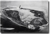 Site 1, Mud Islands viewed from the south. The shelly beach rock is at A, and the eroded salt marsh at B. The arrows sow the entrances to the lagoon and the tidal deltas. |
| Access | Boat | |
| Ownership/Managing Authority | Crown Land. Department of Conservation Forests and Land. | |
Site Description | Mud Islands is a group of sandy islets and shoals, arranged roughly in a circle and enclosing a large, shallow, central lagoon. There are currently (May 1988) 3 tidal openings to the lagoon but the configuration of the group changes rapidly and markedly, due to opening and closing to tidal entrances by storms, beach and dune sand movement, and the growth of salt marsh. Outcrops of salt marsh peat and firm sandy bank parallel to and offshore from the western islands show the position of an earlier island that has been eroded. The islands have a low and level surface rising less than 3 m above high spring tide. The highest parts are beach ridges of shelly sand, capped by finer wind-blown sands on the western margin of the group. The lagoon and salt marsh areas are of fine sandy mud. There are layers of cemented shell beds in the south of the islands and remnants of a formerly thin guano deposit which was quarried for fertilizer last century. | |
Mud Islands has accumulated on an outcrop of dune calcarenite similar to that which outcrops on the Nepean Peninsula and at Point Lonsdale. This outcrop is the only surface expression of the submerged broad platform of the Nepean Bay Bar, which underlies the extensive shoal area at the entrance to Port Phillip Bay. The sediments, moved by tidal currents and wave action, where deposited on the dune rock forming shallow banks and bars on which developed the emergent sandy islets. These in turn provided shallow, sheltered environments for the growth of salt marsh and lagoonal shell species. Unlike other islands in Victorian embayment (eg - Corner Inlet), Mud Islands has not been dependent on marsh vegetation growth for their accumulation - rather the vegetation has developed in sheltered environments provided by the islet accumulation. | ||
Significance | State. This is the only known locality in Port Phillip Bay where consolidated dune rock is exposed above high water mark. The outcrop of cemented beach rock is the only known occurrence in Port Phillip Bay and is unusual on Victorian coasts. Mud Islands is the most obvious surface expression of the Port Phillip Sands, the shoal area overlying the Nepean Bay Bar. The islands are an unusual feature in Victoria and superficially resemble an atoll, although the processes of formation may be more accurately compared with those promoting the growth of sand and shingle spits and ridges on coral platforms. They therefore provide an example of an uncommon type of island development in Victoria. The site is important for the study of sediment movement of the Port Phillip Sands, for demonstrating aspects of sea floor development at the entrance to Port Phillip Bay, for observing the dynamics of tidal inlet development, and for monitoring changes that may be related to rising sea level or altered wave and current conditions in Port Phillip Bay. | |
Management Considerations | Class 1. The islands should be left as dynamic features and a scientific reserve. Reclamation, protective structures, dumping of any materials, construction, quarrying or other modifications to the islands including shoal areas and adjacent waters, that would artificially alter the geomorphology and processes of the area should be prohibited. | |
References | Keble, RA (1947, 1950) Bird, ECF (1973) | |
Site 1, Mud Islands

© State of Victoria (Agriculture Victoria) 1996 - .

This work, Victorian Resources Online, is licensed under a Creative Commons Attribution 4.0 licence. You are free to re-use the work under that licence, on the condition that you credit the State of Victoria (Agriculture Victoria) as author, indicate if changes were made and comply with the other licence terms.
The licence does not apply to ‘branding’ or some ‘images or photographs’ that may be owned by third parties. We ask you to seek prior approval to use images using the VRO feedback form. Access to higher quality images can also be provided on request.
This page was last updated on .