
PP70. Manyung Rocks - Balcombe Clay
|
This information has been developed from one or more of these publications:
|
| Location: | 307707. 800 metres north of Sunnyside Beach, Mt Eliza. Coastal cliff, shore platform, erosion gully. | 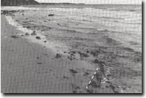 Site 70. Dipping Balcombe Clay along Manyung Fault. |
Access: | Sunnyside Beach Road (south entrance) or Sturion Pde off Kunyung Road (north entrance). | |
Ownership/Managing Authority: | Crown land below high water mark, private land. | |
Site Description: | The coastal cliff and shore platform provide exposures of faulted and folded Tertiary sediments. The sequence has previously been mapped and described in considerable detail and is the subject of ongoing research. The site includes a better exposure of the distinctive calcareous nodules contained in the Balcombe Clay than is available at Fossil Beach. In the shore platform, the beds dip steeply to the northwest due to the effect of drag on the Manyung Fault. Older Volcanics basalt outcrops at the Manyung Rocks headland. The small gully 50 m south of Manyung Rocks includes significant exposures of Balcombe clay overlain by Marina Cove Sand and Baxter Sandstones. | |
North of Manyung Rocks, there is an unusual contact between weathered Older Volcanics basalt and organic rich sediments exposed in a low cliff and on the shore platform. This appears to be a fault or a landslip contact. | ||
Significance: | State. Due to the degradation of the Fossil Beach site, this site is the most significant exposure of the lithology of the Balcombe Clay. The calcareous concretions that are such an unusual component of the Balcombe Clay are more abundant here than any other accessible site. The shore platform exposures provide the most complete section of the Balcombe Clay than any other site on the Mornington Peninsula, with Batesfordian, Balcombian and Bairnsdalian stages being recorded. Apart from Fossil Beach, this is also the only site where the base of the Balcombe Clay can be dated. The gully is an important section to show the stratigraphy of the post-basaltic sediments including the contact between the Baxter Sandstone and Marina Cove Sand. | |
Management Considerations: | Class 1. The cliff, shore platform and gully exposures should be left as geological features. Because significant exposures occur on the shore platform, (and are still a few centimeters under water at all but the lowest tides), their existence is not readily obvious. It is therefore important that no beach nourishment, boulder groynes or walls, or other offshore works that would cover the platform should be undertaken. The gully should be subject to only minimal stabilisation works. | |
References: | Hall, T.S. & Pritchard, G.B. (1901). Some sections illustrating the geological structure of the country about Mornington. Proc. R. Soc. Vict., 14, 32-54. Singleton, F.A. (1941). The Tertiary geology of Australia. Proc. R. Soc. Vict., 53, 1-125. Davies, E.M. (1960). Balcombe Bay - a classic area for Victorian geology. Vict. Nat., 77, 14-18. Gostin, V.A. (1966). Tertiary stratigraphy of the Mornington district, Victoria. Proc. R. Soc. Vict., 79, 459-512. | |
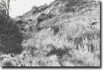 Site 70, Gully exposing Balcombe Clay, Marine Cove Sand and Baxter Formation, outh of Manyung Rocks. | 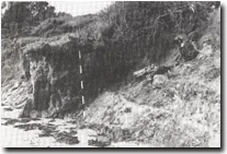 Site 70. Landslip contact north of Manyung Rocks. | |
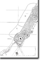
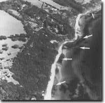 Sites 70, 71, 72. Arrows show significant outcrops that occur in the intertidal zone and are exposed only during very low tides. |

© State of Victoria (Agriculture Victoria) 1996 - .

This work, Victorian Resources Online, is licensed under a Creative Commons Attribution 4.0 licence. You are free to re-use the work under that licence, on the condition that you credit the State of Victoria (Agriculture Victoria) as author, indicate if changes were made and comply with the other licence terms.
The licence does not apply to ‘branding’ or some ‘images or photographs’ that may be owned by third parties. We ask you to seek prior approval to use images using the VRO feedback form. Access to higher quality images can also be provided on request.
This page was last updated on .