
190. Kitty Miller Bay
|
This information has been developed from one or more of these publications:
|
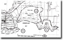
Location: | Pyramid Rock – 404358. 2 km west of Summerland. | |
Access: | Kitty Miller Road. | |
Ownership: | Crown land and some private land. | |
Geology/Geomorphology: | Kitty Miller Bay is one of the most distinctive small embayments on Phillip Island being tightly curved in plan with a narrow bay head beach and a very wide shore platform. Kennon Head is a former basalt island (called Phelan’s Island by Edwards, 1945) now incorporated in the Summerland tombolo complex. The dunes of this tombolo occur on the western shore of the bay. Of geological significance are the two dykes that intrude the basalt platform south and west of Kennon Head and a large breached zeolite chamber over 1.5 m long and 25 cm wide. Agates are often found in the beach gravels near Watt point east of Kitty Miller Bay. At the western entrance the rock platforms are stepped in profile and there is an impressive display of columnar jointed basalt at the edge of the higher platform level. Extending from this platform to the base of bluff is a stranded and vegetated boulder rampart 1 m to 1.5 m above high water mark. The boulders are similar in dimension to those of the modern beaches (up to 20 cm long) and appear to have been emplaced by storm waves at a slightly higher sea level than at present. | |
Significance: | State. The site has several significant features in close proximity that are readily accessible for field study. | |
Management: | Class 2. Present access arrangements are consistent with maintaining the significance of the site. The use of heavy equipment (i.e. larger than geological hammers) to search for zeolites and agates should be prohibited as should the commercial extraction of these materials. | |

© State of Victoria (Agriculture Victoria) 1996 - .

This work, Victorian Resources Online, is licensed under a Creative Commons Attribution 4.0 licence. You are free to re-use the work under that licence, on the condition that you credit the State of Victoria (Agriculture Victoria) as author, indicate if changes were made and comply with the other licence terms.
The licence does not apply to ‘branding’ or some ‘images or photographs’ that may be owned by third parties. We ask you to seek prior approval to use images using the VRO feedback form. Access to higher quality images can also be provided on request.
This page was last updated on .