
49. Jacks Beach - Silurian and Tertiary Outcrops
|
This information has been developed from one or more of these publications:
|
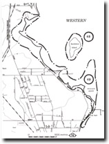
| Location: | Tyabb – 425572 to 442535. The site includes the coastal wetlands and tidal flats south from Reid Parade to the south of the Crib Point jetty. | 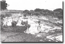 Folded Silurian strata, Woolleys Beach, Site 49 |
Access: | Reid Parade, Woolleys Road, and The Esplanade. | |
Ownership: | Crown Land and some private land. | |
Geology/Geomorphology: 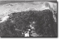 Folded Silurian Strata, Site 49 | Silurian sedimentary rocks underly the area and are well displayed at Golden Point immediately north of Woolleys Beach. This outcrop includes steeply dipping and folded beds which are the most extensive outcrop of Silurian strata on the entire mainland shoreline of Westernport Bay. Smaller outcrops are at Jacks Beach and on the small un-named point one kilometre to the north-west. Well bedded and cross-bedded ferruginous rocks and grits of the Tertiary Baxter Formation are well displayed to the north and south of the Crib Point jetty. | |
The influence of the hard rock outcrops on coastal morphology is apparent in the cusp-shaped headlands north-west of Woolleys Beach. Salt marsh peats and muds and mangrove muds have largely infilled the estuary of the Warenquite Creek and in part mantle the Silurian outcrops. The inner margin of the coastal deposits is a low bluff that is best defined between Woolleys Beach and Jacks Beach. Sand and gravel derived from the break-up of the Baxter formation have formed beaches adjacent to the Crib point jetty and these are augmented by shell fragments from the extensive shell banks that lie on the inter-tidal mudflats north of the jetty. | ||
Significance: | State. The Silurian outcrops are the most extensive of this strata on the mainland shore of Westernport Bay. There is also a major display of the Tertiary strata (Baxter Formation) and both are readily accessible as reference sites for these materials. The bank of tidal overwash shells and shell sands that extends north from the Crib Point Jetty is easily accessible at low tide as the substrate is quite firm. This provides a rare opportunity to examine this material and its depositional structures without the need for boat transport. | |
Management: | Class 1. Any extension to coastal facilities must be planned to avoid obscuring the Silurian and Tertiary outcrops or disturbing the shell banks north of the jetty. Dumping of dredged material in the area and land reclamation schemes should be prohibited. | |
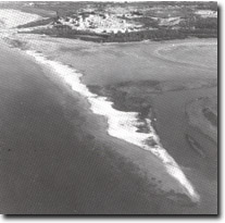 Tidal overwash shell banks north of Crib Point Jetty, Site 49 |

© State of Victoria (Agriculture Victoria) 1996 - .

This work, Victorian Resources Online, is licensed under a Creative Commons Attribution 4.0 licence. You are free to re-use the work under that licence, on the condition that you credit the State of Victoria (Agriculture Victoria) as author, indicate if changes were made and comply with the other licence terms.
The licence does not apply to ‘branding’ or some ‘images or photographs’ that may be owned by third parties. We ask you to seek prior approval to use images using the VRO feedback form. Access to higher quality images can also be provided on request.
This page was last updated on .