
172. Homestead Point - Prograding Beach
|
This information has been developed from one or more of these publications:
|
Location: | Woolamai – 560351. 1 km south-west of New Haven. | 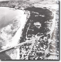 Prograding beach ridges (A) enclosing the Newhaven Swamp, Site 172 |
Access: | Bridge View Drive. | |
Ownership: | Crown land. | |
Geology/Geomorphology: | Homestead Point is an outcrop of deeply weathered Older Volcanics with strong ferruginization of the joint planes and development of large clay clasts. North of the point a former embayment (marked by a bluff 150 m inland) is now enclosed by beach ridges which enclose the (generally dry) Newhaven Swamp. The beach is distinctive for the sequence of prograding beach ridges over 100 m wide developing at the southern end. The outermost ridge is broad and low with a cover of Spinifex, Agropyron and to a lesser extent Ammophila. | |
Significance: | State. The coast is a major example of a prograding sandy beach ridge shoreline. It is one of the few such sectors on the Victorian coast and is particularly significant as it is not related to an adjacent artificial structure. | |
Management: | Class 2. Extension of the caravan park (in the north of the site) along the coast should not be permitted. Vehicles should be prohibited from the dune area and no harbour facilities should be constructed between The Narrows bridge and Manuka Point. The New haven Swamp should be managed as a wildlife reserve and public access restricted to a footpath from Bridge View Road to Homestead Point, to avoid excessive damage to the area by unrestricted vehicle use. | |

© State of Victoria (Agriculture Victoria) 1996 - .

This work, Victorian Resources Online, is licensed under a Creative Commons Attribution 4.0 licence. You are free to re-use the work under that licence, on the condition that you credit the State of Victoria (Agriculture Victoria) as author, indicate if changes were made and comply with the other licence terms.
The licence does not apply to ‘branding’ or some ‘images or photographs’ that may be owned by third parties. We ask you to seek prior approval to use images using the VRO feedback form. Access to higher quality images can also be provided on request.
This page was last updated on .