
PP77. Harmon Rocks - Geological Section
|
This information has been developed from one or more of these publications:
|
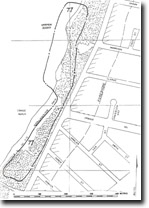
| Location: | 272642. Small promontory (Harmon Rocks) and cliffs to the south behind Craigie Beach, (approximately between Parer St and Shanns Ave, Mt Martha). | 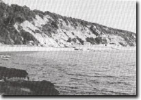 Site 77. Tertiary sediments, cliffs south of Harmon Rocks, Mornington. |
Access.: | Coastal paths from The Esplanade opposite Shanns Ave or Helena St, Mt Martha. | |
Ownership/Managing Authority: | Crown land, Shire of Mornington. | |
| Site Description: | The site exposes several of the Tertiary formations that comprise the surface geology of the central Mornington Peninsula. The exposures are in coastal cliffs rising over 30 m above high water mark and extending from north of Harmon Rocks 300 m to the south behind Craigie Beach to Hawker Beach. The basal materials are Older Volcanic basalt which forms the cliff base and platform at Harmon Rocks, and contributes the majority of the cobbles of the storm beach extending 150 m south of that point. The basalt has many horizontal and vertical joints, some filled by siderite veins. To the top, the basalt is soft and weathered and becomes white. The weathered basalt is overlain by various sedimentary beds, the sequence being a thin bed of ‘Post-Basaltic Sediments’, 10 m of Mt Martha Sand Beds, 2 m Harmon Rocks Sand Bed, thin Balcombe Clay and Marina Cove Sand and a 10 m thick sequence of Baxter Formation. In places the cliffs are deeply gullied and there are landslips that disrupt the sequence of beds. | |
Significance: | State. This is a major display of Middle Tertiary stratigraphy. All of the post-Older Volcanic sediments of the Mornington Peninsula are represented and the exposures, although often difficult to access, are clear and extensive. The site is important as a teaching site for stratigraphic and sedimentology studies as well as providing clear examples of degrees of weathering and ferruginization of sedimentary and volcanic rocks. | |
Management Considerations: | Class 1. Because landslips and dense vegetation obscure part of the cliff, no single site is suitable for measuring the complete sequence. It is necessary to maintain the whole length to record sufficient exposures to determine the succession of beds. To maintain the clarity of the exposure, coastal protection and cliff stabilization work should b kept to a minimum. No sea walls or other construction should be built at Harmon Rocks or across the storm beach to the south, and quarrying or removal of volcanic rock should be prohibited. Management of the site for public display of geological features should take precedence over protection of private boat sheds at Craigie Beach. These structures should be removed, the sea wall not be extended to the north and ‘normal’ marine and subaerial processes allowed to operate on the cliffs. No dumping of protective boulders or foreign materials on the cliffs or beach should take place. | |
References: | Gostin, V.A. (1966). Tertiary stratigraphy of the Mornington district, Victoria. Proc. R. Soc. Vict., 79. 459-512. | |
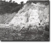 Site 77. Older Volcanics basalts, Harmon Rocks. | 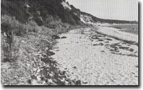 Site 77, Storm beach of basalt gravels south of Harmon Rocks. |

© State of Victoria (Agriculture Victoria) 1996 - .

This work, Victorian Resources Online, is licensed under a Creative Commons Attribution 4.0 licence. You are free to re-use the work under that licence, on the condition that you credit the State of Victoria (Agriculture Victoria) as author, indicate if changes were made and comply with the other licence terms.
The licence does not apply to ‘branding’ or some ‘images or photographs’ that may be owned by third parties. We ask you to seek prior approval to use images using the VRO feedback form. Access to higher quality images can also be provided on request.
This page was last updated on .