
PP66. Half Moon Bay Point (Mt Eliza) - Cliff and Platform
|
This information has been developed from one or more of these publications:
|
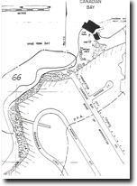
| Location: | 316729. Headland between Ranelagh Beach and Half Moon Bay, Mt Eliza. | 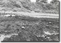 Site 66. Apparent southerly dip of Baxter Formation, Half Moon Bay, Mt Eliza |
Access: | Canadian Bay Road, Mt Eliza. | |
Ownership/Managing Authority: | Crown land, Shire of Mornington | |
Site Description: | The site includes undercut cliffs, bluffs, a wide shore platform and backshore platform features. The most unusual feature of the site is the structure on the shore platform where ferruginous Baxter Formation sediments appear to form an anticline. Near the cliffs at Canadian Bay Road, the beds dip northeast while 100 m to the south they appear to dip to the southwest. This ‘apparent’ dip may be due to cross-bedding of sandstones. To the south of Canadian Bay Road, the cliffs decline to be scrub covered bluffs behind a wide, cobble and boulder strewn shore platform with several benched levels. These levels may be remnant platform surfaces developed at higher sea levels, but are in part structurally controlled by the cross-bedding and dip of the sandstones. There are intricate weathering patterns on the sandstone of the platform reflecting the variable composition and structure of the Baxter Formation. | |
Significance: | State. The site is an excellent display of the Baxter Formation and an important locality to show the lithological and structural character of that formation. It also has the most complex shore platform structure (geomorphologically and structurally) of any site in Port Phillip Bay. There are several platform levels that have been interpreted as indicating possible higher sea level sites. | |
Management Considerations: | Class 1. The cliffs and platform should be maintained as active coastal landforms. The most significant elements of the site are related to the shore platform, so no protective structures should be built that would obscure these. A formalised footpath leading to the southern shores of the cliffs would improve access, but this should be sited so as not to obscure the significant boulder beds on the raised platform surfaces. | |
References: | Gostin, V.A. (1966). Tertiary stratigraphy of the Mornington district, Victoria. Proc. R. Soc. Vict., 79. 459-512. | |
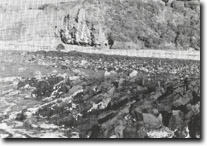 Site 66. Apparent northerly dip of Baxter Formation (Half Moon Bay, Mt Eliza) | 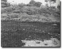 Site 66. Benched platform levels north of Ranelagh Beach, Mt Eliza |
 Site 66. Half Moon Bay - north of Ranelagh Beach (Mt Eliza) Site 66. Half Moon Bay - north of Ranelagh Beach (Mt Eliza) | 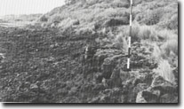 Site 66. Detail of apparent higher level platform surface, North of Ranelagh Beach, Mt Eliza |

© State of Victoria (Agriculture Victoria) 1996 - .

This work, Victorian Resources Online, is licensed under a Creative Commons Attribution 4.0 licence. You are free to re-use the work under that licence, on the condition that you credit the State of Victoria (Agriculture Victoria) as author, indicate if changes were made and comply with the other licence terms.
The licence does not apply to ‘branding’ or some ‘images or photographs’ that may be owned by third parties. We ask you to seek prior approval to use images using the VRO feedback form. Access to higher quality images can also be provided on request.
This page was last updated on .