
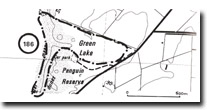
186. Green Lake - Swamp and Dunes
|
This information has been developed from one or more of these publications:
|
Location: | Somers 389372 to Pyramid Rock 384368. 1 km north of Summerland. | |
Access: | Car park of Ventnor Road, 1 km north-east of Summerland. | |
Ownership: | Crown land. | |
Geology/Geomorphology: | This is a wetland similar in origin to McHaffies Lagoon and Flynn Lagoon but there is no area of open water. The enclosing dunes are dominantly calcareous and have a clearly defined inner margin where they abut the Green Lake wetland. A former lake has been drained by development and maintenance of an outlet or overflow channel through the dune system and this channel has incised into the volcanic material which forms the terrain basement. The volcanics crop out in the cliffs south of the outlet channel, their upper surface marked in places by red gravelly accumulations and by springs that issue from the base of the overlying dune sands. Although well rounded black basalt pebbles are lodged in the cliff face above high water mark, sand is no longer being added from the beach system into the dunes in any significant quantity. Hence, the active transgressive phase of dune development has ceased and the dunes are relict cliff top features of very recent origin. | |
Significance: | State. The dynamics and situation of the dune system differs from that of other sections of Phillip Island. The ability of a minor channel to maintain itself through the dune system is unusual in the state context, as is the very recent nature of stranding of the cliff-top dunes. | |
Management: | Class 2. Minimal disturbance to the area is required to maintain the equilibrium of the dune and wetland systems. Pedestrian traffic should be excluded from the dune area and this would be facilitated by closing the road to the Green Lake parking area. | |

© State of Victoria (Agriculture Victoria) 1996 - .

This work, Victorian Resources Online, is licensed under a Creative Commons Attribution 4.0 licence. You are free to re-use the work under that licence, on the condition that you credit the State of Victoria (Agriculture Victoria) as author, indicate if changes were made and comply with the other licence terms.
The licence does not apply to ‘branding’ or some ‘images or photographs’ that may be owned by third parties. We ask you to seek prior approval to use images using the VRO feedback form. Access to higher quality images can also be provided on request.
This page was last updated on .