
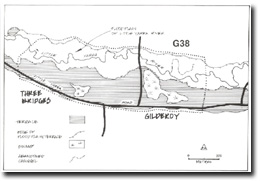
G38 - Three Bridges and Gilderoy - Terrace and Swamps
|
This information has been developed from the publications:
|
| Location: | AMG Ref: 856095. | 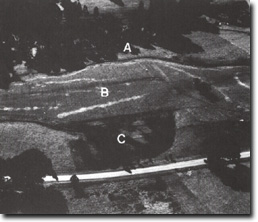 Little Yarra River floodplain (A), terrace (B), swamp (C) at Site G38. |
Access: | Yarra Junction - Noojee Road. | |
Geomorphology: | This area includes the longest distinct terrace along the Little Yarra River. In places, the terrace surface slopes south, i.e. away from the floodplain and this has allowed swamps to develop at the back of the terrace. | |
Two examples of this are included in this site at Gilderoy and Three Bridges. | ||
Significance: | Regional. | |
Management: | Class 2. The area of swamp on the Public Land portion of this site should not be drained or further cleared. No other land use restriction is necessary on other parts of the site. | |
Three Bridges

© State of Victoria (Agriculture Victoria) 1996 - .

This work, Victorian Resources Online, is licensed under a Creative Commons Attribution 4.0 licence. You are free to re-use the work under that licence, on the condition that you credit the State of Victoria (Agriculture Victoria) as author, indicate if changes were made and comply with the other licence terms.
The licence does not apply to ‘branding’ or some ‘images or photographs’ that may be owned by third parties. We ask you to seek prior approval to use images using the VRO feedback form. Access to higher quality images can also be provided on request.
This page was last updated on .