
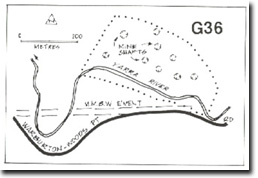
G36 - Upper Yarra - Gravel Terrace
|
This information has been developed from the publications:
|
| Location: | AMG Ref: 004297. | |
Access: | Upper Yarra Dam Road. | |
Geomorphology: | A low gravel terrace north of the river has the remains of numerous shallow mining pits and shafts testifying to the presence of alluvial gold in the abandoned river channels. | |
Significance: | Local. The site is of interest for the evidence of alluvial mining. | |
Management: | Class 2. No gravel extraction should be permitted in the area of the site. | |
Upper Yarra - Gravel Terrace

© State of Victoria (Agriculture Victoria) 1996 - .

This work, Victorian Resources Online, is licensed under a Creative Commons Attribution 4.0 licence. You are free to re-use the work under that licence, on the condition that you credit the State of Victoria (Agriculture Victoria) as author, indicate if changes were made and comply with the other licence terms.
The licence does not apply to ‘branding’ or some ‘images or photographs’ that may be owned by third parties. We ask you to seek prior approval to use images using the VRO feedback form. Access to higher quality images can also be provided on request.
This page was last updated on .