
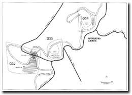
G33, G34 - Abandoned Incised Meanders
|
This information has been developed from the publications:
|
| Location: | AMG Ref: G33 - 965263, G34 - 968267. | 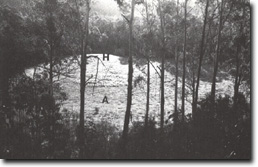 Abandines meander channel (A) with gravel-capped hill (H) as meander core at Site G33. |
Access: | From Woods Point Road. | |
Geomorphology: | The site encloses abandoned higher level meanders that lie on gravel terraces 10 metres above river level. Each has a low rounded hill at the core of the meander. | |
Significance: | Regional. The Two examples cited are easily accessible examples of the process of valley widening in the Upper Yarra Valley. | |
Management: | Class 2. G33 is more readily discerned than G34 and displays a sequence of gravel terraces, for example the hill forming the meander core is capped by fluvial gravels. land use at G33 should be compatible with maintaining the display of slopes and channels. No land use constraint is suggested for G34. | |
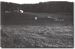 Abandoned channel (A) of fromer meander at McMahons Creek at Site 34. |

© State of Victoria (Agriculture Victoria) 1996 - .

This work, Victorian Resources Online, is licensed under a Creative Commons Attribution 4.0 licence. You are free to re-use the work under that licence, on the condition that you credit the State of Victoria (Agriculture Victoria) as author, indicate if changes were made and comply with the other licence terms.
The licence does not apply to ‘branding’ or some ‘images or photographs’ that may be owned by third parties. We ask you to seek prior approval to use images using the VRO feedback form. Access to higher quality images can also be provided on request.
This page was last updated on .