
G31 - Diversion Tunnel
|
This information has been developed from the publications:
|
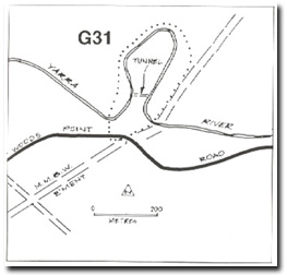
| Location: | AMG Ref: 948244. | 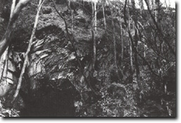 Rock bending due to soil slumping above diversion tunnel at Site G31. |
Access: | Warburton - Woods Point Road. | |
Geology/Geomorphology: | A narrow meander spur exposes beds of Norton Gully sandstone that strike north-north-west. A diversion tunnel links the river channel through the neck of the spur although flow is still maintained around the meander loop. The tunnel provides clear exposure of the bedrock of the Upper Yarra Valley. An example of rock bending due to soil slumping can be seen on the western tunnel portal. | |
Significance: | Local. (See Site G32). | |
Management: | Class 2. Maintenance of the access tracks to divert traffic away from the areas prone to soil slumping is necessary. | |
diversion Tunnel

© State of Victoria (Agriculture Victoria) 1996 - .

This work, Victorian Resources Online, is licensed under a Creative Commons Attribution 4.0 licence. You are free to re-use the work under that licence, on the condition that you credit the State of Victoria (Agriculture Victoria) as author, indicate if changes were made and comply with the other licence terms.
The licence does not apply to ‘branding’ or some ‘images or photographs’ that may be owned by third parties. We ask you to seek prior approval to use images using the VRO feedback form. Access to higher quality images can also be provided on request.
This page was last updated on .