
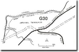
G30 - Crooked Creek - Gravel Terrace
|
This information has been developed from the publications:
|
| Location: | AMG Ref: 935247. | 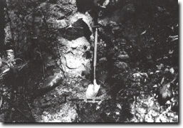 Bedrock surface (T-T) at Site G30. |
Access: | From Warburton - Woods Point Road. | |
Geomorphology: | The site includes road cuttings on the Warburton - Woods Point Road and the slopes adjacent to the Yarra River east of Crooked Creek. These comprise a complex of alluvial fan and channel gravels that rest on a truncated bedrock surface. | |
Significance: | State. The site clearly illustrates the process operative in the development of valleys on the Great Dividing Range. These include episodes of incision alternating with aggradation and channel filling, the fill being partly derived from alluvial fans and slope colluvium. | |
Management: | Class 2. Some quarrying of the gravels could be permitted as this exposes the contact between bedrock and overlying gravels. Other land use activities would not be compatible with maintaining the significance of the site. | |
Crooked Creek

© State of Victoria (Agriculture Victoria) 1996 - .

This work, Victorian Resources Online, is licensed under a Creative Commons Attribution 4.0 licence. You are free to re-use the work under that licence, on the condition that you credit the State of Victoria (Agriculture Victoria) as author, indicate if changes were made and comply with the other licence terms.
The licence does not apply to ‘branding’ or some ‘images or photographs’ that may be owned by third parties. We ask you to seek prior approval to use images using the VRO feedback form. Access to higher quality images can also be provided on request.
This page was last updated on .