
G29 - Flood Channels
|
This information has been developed from the publications:
|
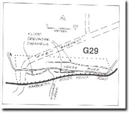
| Location: | AMG Ref: 925243. 500 metres downstream from O'Sannassy Road. | 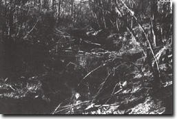 Flood chute at Site 29. |
Access: | Woods Point Road. | |
Geomorphology: | Several flood channels issue from the crevasse o the river bank. The channels are choked with boulders, gravels and fallen timber. | |
Significance: | Local. The site is a clear example of the process of channel change in the Yarra Valley upstream from Warburton. | |
Management: | Class 2. The site should not be subject to actions that will destroy the form of the flood chutes e.g. filling or gravel/sand extraction. | |
 Flood Channels

© State of Victoria (Agriculture Victoria) 1996 - .

This work, Victorian Resources Online, is licensed under a Creative Commons Attribution 4.0 licence. You are free to re-use the work under that licence, on the condition that you credit the State of Victoria (Agriculture Victoria) as author, indicate if changes were made and comply with the other licence terms.
The licence does not apply to ‘branding’ or some ‘images or photographs’ that may be owned by third parties. We ask you to seek prior approval to use images using the VRO feedback form. Access to higher quality images can also be provided on request.
This page was last updated on .