
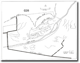
G26 - Millgrove - Straight Channel Reach; Terraces
|
This information has been developed from the publications:
|
| Location: | AMG Ref: 795195. | 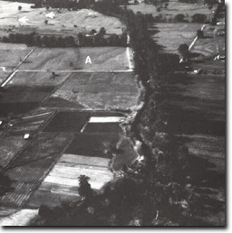 Abandoned channel patterns (A), and straight channel reach at Site G26. arrows show edge of terraces. |
Access: | Station Road. | |
Geomorphology: | A three kilometre reach of the Yarra River below Millgrove is flanked by terraces on the northern bank. The terraces are not present south of the river. The lower terrace surface displays a complex pattern of anastamosing relict channels that contrast with the modern long straight channel pattern. The site is of particular interest for the absence of meanders. | |
Significance: | Regional. The long straight channel sector is unusual and contrasts with the well defined meander patterns downstream. | |
Management: | Class 2. Close subdivision on the terrace margins and the areas of abandoned channel on the north of the river would essentially obscure the significant geomorphological features of this site. Maintenance of present land use intensity is preferred. |
Milgrove - Straight Channel Reach

© State of Victoria (Agriculture Victoria) 1996 - .

This work, Victorian Resources Online, is licensed under a Creative Commons Attribution 4.0 licence. You are free to re-use the work under that licence, on the condition that you credit the State of Victoria (Agriculture Victoria) as author, indicate if changes were made and comply with the other licence terms.
The licence does not apply to ‘branding’ or some ‘images or photographs’ that may be owned by third parties. We ask you to seek prior approval to use images using the VRO feedback form. Access to higher quality images can also be provided on request.
This page was last updated on .