
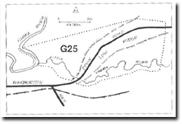
G25 - Yarra River - Little Yarra River Junction
|
This information has been developed from the publications:
|
| Location: | AMG Ref: 755182. | 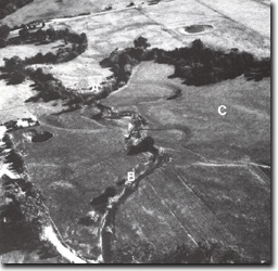 The junction of the Yarra River (A) and Little Yarra River (B), is deflected by the low ridge (C) which is a terrace remnant. |
Access: | Doon Road. | |
Geomorphology: | The junction of the two streams is deferred by a low and distinct alluvial ridge that is traversed by Doon Road. The ridge may be a remnant of a low terrace or levee of the Yarra River. | |
Significance: | Local. | |
Management: | Class 3. No restriction on land use is necessary to maintain the significance of the site. |
Yarra River - Little Yarra River Junction

© State of Victoria (Agriculture Victoria) 1996 - .

This work, Victorian Resources Online, is licensed under a Creative Commons Attribution 4.0 licence. You are free to re-use the work under that licence, on the condition that you credit the State of Victoria (Agriculture Victoria) as author, indicate if changes were made and comply with the other licence terms.
The licence does not apply to ‘branding’ or some ‘images or photographs’ that may be owned by third parties. We ask you to seek prior approval to use images using the VRO feedback form. Access to higher quality images can also be provided on request.
This page was last updated on .