
218. Freeman Point - Baxter Formation
|
This information has been developed from one or more of these publications:
|
Location: | Palmer - 650522. The site extends from 1.5 km west of Freeman Point to 2 km east of Freeman Point. | 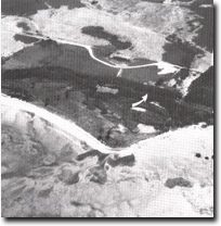 Sandy cuspate foreland west of Freeman Point. Arrow indicates coastal bluff, Site 218. |
Access: | McLeod Road and walk along the beach from Freeman Point. | |
Ownership: | Crown land. | |
Geology/Geomorphology: | West of Freeman Point the coast is low and sandy and there is a sandy cuspate foreland over 200 m wide. Behind this is a low coastal bluff. East of Freeman Point there are cliffs ranging from 3 to 10 m in height eroded into Upper Tertiary Baxter Formation sediments. | |
Significance: | State. The cliffs in Baxter Formation exposed in the site offer excellent vertical sections through the various members of the Baxter Formation. No detailed investigations of the stratigraphy have been conducted and it is essential that representative sections be preserved for this purpose. The sandy cuspate foreland is an excellent example of this feature and is one of a complex of sandy depositional forms on the south-east coast of French Island. | |
Management: | To maintain the outcrop it is essential that no quarrying or removal of sediment be permitted from this site. The cliffs vary from active to inactive sectors, and construction of sea walls or erosion protection structures should be prohibited as this would allow accumulation of weathered products on the cliff face and would mask the outcrops. No buildings should be permitted on the cuspate foreland and quarrying of sand should be prohibited. | |

© State of Victoria (Agriculture Victoria) 1996 - .

This work, Victorian Resources Online, is licensed under a Creative Commons Attribution 4.0 licence. You are free to re-use the work under that licence, on the condition that you credit the State of Victoria (Agriculture Victoria) as author, indicate if changes were made and comply with the other licence terms.
The licence does not apply to ‘branding’ or some ‘images or photographs’ that may be owned by third parties. We ask you to seek prior approval to use images using the VRO feedback form. Access to higher quality images can also be provided on request.
This page was last updated on .