
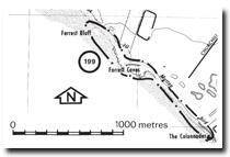
199. Forrest Bluff and Caves
|
This information has been developed from one or more of these publications:
|
Location: | Woolamai – 528346. 2 km west of Woolamai Waters. | |
Access: | Churchill Road. | |
Ownership: | Crown land and private land. | |
Geology/Geomorphology: | Highly fractured basalt is overlain by weathered tuff which at Forrest Bluff forms steep and unstable earth cliffs 15 m high. The Shearwater Observatory is sited close to a cliff sector where the rate of cliff recession in these easily erodible materials appears to be relatively rapid. Forrest Caves are tunnels extending into the shore platform across a mass of fallen basalt and tuff blocks. 200 m to the east the tuffs are overlain in the cliff top by a 2 to 4 m thick bed of white sandy clay similar to beds below the dunes at Cat Bay. Jenkin (1974) regarded these as extensions of the Warneet Beds. At The Colonades in the south-east of the site are basalt columns 6 to 8 m high. | |
Significance: | Regional. Despite the steep and exposed nature of the south coast of Phillip Island sea caves are poorly developed. Forrest Caves therefore represent an accessible example of this landform. The earth cliffs near the Shearwater Observatory possibly represent some of the most rapidly eroding cliff sectors in the Westernport area. | |
Management: | Class 2. Restriction of vehicle movements and diversion of pedestrian traffic to better defined access ways are necessary to prevent degradation of the dunes and coastal bluffs. | |

© State of Victoria (Agriculture Victoria) 1996 - .

This work, Victorian Resources Online, is licensed under a Creative Commons Attribution 4.0 licence. You are free to re-use the work under that licence, on the condition that you credit the State of Victoria (Agriculture Victoria) as author, indicate if changes were made and comply with the other licence terms.
The licence does not apply to ‘branding’ or some ‘images or photographs’ that may be owned by third parties. We ask you to seek prior approval to use images using the VRO feedback form. Access to higher quality images can also be provided on request.
This page was last updated on .