
12 Edwards Point - Spit Complex
|
This information has been developed from one or more of these publications:
|
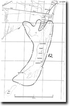
| Location | 985671 to 985675. Narrow, branching peninsula extending 3 km into, and forming the northern enclosure of Swan Bay. | 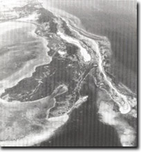 Site 12, Recurving spits, lagoons at Edwards Point |
| Access | Lower Bluff Road (off Bluff Road, St Leonards). | |
| Ownership/Managing Authority | Crown land, Department of Conservation, Forests and Lands, (Edwards Point Flora and Fauna Reserve). | |
| Site Description | Edwards Point is a compound, branching barrier/spit system, with the proximal end anchored against the bluff at the north of Swan Bay. There are three major ridge systems, separated by marshy swales and containing numerous smaller lagoons. The distal ends of the ridges recurve into Swan Bay and have broad tidal flat extensions. These extensions may be the submerged remnants of a formerly more extensive system (now eroded) or may indicate that deposition is now actually extending the spit complex, as there is evidence that the southeastern spit has prograded since late last century. The ridges are composed of sand, shell fragments and ironstone gravels, the latter material being derived from erosion of coastal outcrops to the north. An elongated lagoon, enclosed by a narrow, marshy barrier, lies between the westernmost ridge and the bluff to the north of Edwards Point. This lagoon is included as part of the depositional complex. | |
Significance | State. Along with Swan Island, Edwards Point comprises part of the most complex depositional feature on the coast of Port Phillip Bay. It is of composite origin and contains a wide variety of lithic and biogenic sediments. It is a very large scale and obvious example of depositional processes associated with the sediment-active environment near the entrance to the Bay. It is therefore an important indicator of both long term and short term sedimentation regimes here. | |
Management Considerations | Class 1. The area should be maintained without major physical interference to the onshore and near shore components. Dredging, dumping of spoil, drainage or reclamation would detract substantially from the dynamic character of the site. The shoreline should not be artificially protected or nourished but should be allowed to remain as a natural indicator of sediment regime and shoreline stability. It should be noted that the site includes intertidal areas to the south and west of the emerged body of Edwards Point. | |
References | Barson, M.M. (1973) Bird, E.C.F. (1980) | |
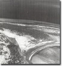 Site 12, Barrier and lagoon west of Edwards Point |

© State of Victoria (Agriculture Victoria) 1996 - .

This work, Victorian Resources Online, is licensed under a Creative Commons Attribution 4.0 licence. You are free to re-use the work under that licence, on the condition that you credit the State of Victoria (Agriculture Victoria) as author, indicate if changes were made and comply with the other licence terms.
The licence does not apply to ‘branding’ or some ‘images or photographs’ that may be owned by third parties. We ask you to seek prior approval to use images using the VRO feedback form. Access to higher quality images can also be provided on request.
This page was last updated on .