
PP64. Daveys Bay - Manyung Fault
|
This information has been developed from one or more of these publications:
|
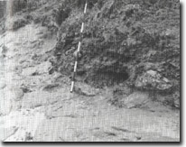
Location: | 335745. Daveys Bay extending from approximately 250 m north of the steps at the end of Gulls Way to the headland 250 m south of Kackeraboite Creek. | 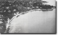 Site 64, Daveys Bay. Selwyn Fault (arrowed), Kackeraboite Creek (A) |
Access: | Gulls Way. | |
Ownership/Managing Authority: | Crown land, City of Frankston. | |
Site Description: | The site includes contrasting geology and the important tectonic structure of the Manyung Fault, part of the main Selwyn Fault system. The small point north of Gulls Way, is of partially weathered basalt faulted against granite and overlain by a 2 m conglomerate bed. The fault zone trends parallel to the coast, is over one metre wide and contains sheared and weathered coarse sandy gravel. Weathering along the fault zone has produced the spines of rock projecting at the point. Weathered granite outcropping at sea level between the point and the steps at Gulls Way is overlain by a ferruginous conglomerate, and basalt occurs in the shore platform. South of the steps, there is fresh, fractured granite in the valley of Kackeraboite Creek. Basalt overlies the granite high in the cliff south of the creek, indicating that the fault passes inland here. The cliffs south of the creek are part of a slump amphitheatre coinciding with the fault zone. Balcome Clay beds outcrop at low water mark beneath Marina Cove Sand and Baxter Formation sandstone. | |
Significance: | State. The site is a major exposure of the geological effect of the Selwyn Fault, the principal tectonic structure on the eastern coast of Port Phillip Bay. It is also an outstanding example of a fault to show stratigraphic displacement and shearing of the fault zone. The geology is complex and the site is an excellent one for advanced earth science teaching. The structure of the fault zone exposed in the small point and cliffs has posed an interpretation issue for several generations of geologists. | |
Management Considerations: | Class 1. No engineering or landscaping works should be permitted along this coastal sector. Because much of the significant material is at sea level, seawalls or boulder defences should not be undertaken as these would add foreign material and mask and confuse the interpretation of the outcrops. Building sites and other land use adjacent to the coast needs to be strictly controlled to avoid the need for engineering structures that would infringe on the display of the geological features. The building of private walkways and facilities over the site should not be permitted. | |
References: | Kitson, A.E. (1900). Report on the coastline and adjacent country between Frankston, Mornington and Dromana. Geol. Surv. Vict. Prog. Rep. 12. 1-13. Hall, T.S. & Pritchard, G.B. (1901). Some sections illustrating the geological structure of the country about Mornington. Proc. R. Soc. Vict., 14. 32-54. Gostin, V.A. (1966). Tertiary stratigraphy of the Mornington district, Victoria. Proc. R. Soc. Vict., 79. 459-512. | |
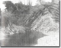 Site 64. Jointed granite, Kackeraboite Creek. | 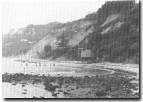 Site 64, Faulted basalt along the line of the Manyung Fault (arrowed). Daveys Bay. |
 Site 64. Conglomerate overlying weathered granite, Daveys Bay | Site 64. Faulted granite cliffs. Daveys Bay |

© State of Victoria (Agriculture Victoria) 1996 - .

This work, Victorian Resources Online, is licensed under a Creative Commons Attribution 4.0 licence. You are free to re-use the work under that licence, on the condition that you credit the State of Victoria (Agriculture Victoria) as author, indicate if changes were made and comply with the other licence terms.
The licence does not apply to ‘branding’ or some ‘images or photographs’ that may be owned by third parties. We ask you to seek prior approval to use images using the VRO feedback form. Access to higher quality images can also be provided on request.
This page was last updated on .