
194. Cunningham Bay - Jessie Island
|
This information has been developed from one or more of these publications:
|
Location: | Pyramid Rock – 463362 to 456350. Coastal area extending approximately 2 km south of The Gap. | 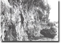 Undercut active cliff in Older Volcanics tuff, Cunningham Bay, Site 194 |
Access: | The Gap Road. | |
Ownership: | Crown land | |
Geology/Geomorphology: | The coastal cliffs here are formed in an unusual array of volcanic materials and include red and purple and brown tuffs and agglomerates. In places a cliff base notch has developed in these materials and large irregular blocks fall from the overhang. The cliff base frequently has a sloping platform with a veneer of gravels including numerous pebbles of granite. A small dyke, excellent examples of corestone formation and terraces 3 to 4 m above high water mark add to the significance of the site. Jessie Island is a large rock stack of tuff with a basalt base. 600 m to the south-west, a headland with a basement of hard basalt overlain by tuff that dips landward is in the process of being isolated to form a cliff stack. | |
Significance: | Regional. The site includes unusual coastal forms, such as the notched cliffs, and a range of colour and weathering patterns in the tuff beds of the Older Volcanics not recorded elsewhere in the study area. The developed and the incipient cliff stack make interesting contrasts in rates of shoreline change. | |
Management: | Class 3. Construction of shore protection works is not needed or warranted as these would obscure significant features. Any construction or roadworks on adjacent private land that would generate waste materials on the area of the site should be prohibited. | |
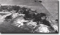 Small headland in the process of being isolated (arrowed) to from a cliff stack south of Jessie Island, Site 194 |

© State of Victoria (Agriculture Victoria) 1996 - .

This work, Victorian Resources Online, is licensed under a Creative Commons Attribution 4.0 licence. You are free to re-use the work under that licence, on the condition that you credit the State of Victoria (Agriculture Victoria) as author, indicate if changes were made and comply with the other licence terms.
The licence does not apply to ‘branding’ or some ‘images or photographs’ that may be owned by third parties. We ask you to seek prior approval to use images using the VRO feedback form. Access to higher quality images can also be provided on request.
This page was last updated on .