
76. Cranbourne - Cranbourne Sand Type Locality
|
This information has been developed from one or more of these publications:
|
| Location: | Devon Meadows – 492773. Two kilometres south of Cranbourne. | 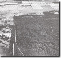 Cranbourne Sand topography near Cranbourne. In the background the area has been cleared of native vegetation, Site 76. |
Access: | Botanic Drive. | |
Ownership: | Crown Land. | |
Geology/Geomorphology: | The site includes low ridges and swampy depressions with a heath or scrub and woodland vegetation. The ridges of fine grained, yellow stained quartz sands. The composition, bedding, and configuration of the deposits indicates they originated as dunes (Jenkin, 1962), and are part of an extensive belt of aeolian sands trending north-west south-east between Tooradin and Cranbourne. They have been referred to stratigraphically as the Cranbourne Sand (Jenkin, 1962). | |
Significance: | State. This site contains one of the most extensive areas of relatively undisturbed Cranbourne Sand topography in the mainland section of the Westernport Bay catchment. As well as being distinctive examples of aeolian terrain, the Cranbourne Sand also played a role in the development of the Koo-Wee-Rup Swamp. | |
Management: | Class 1. No activities that would disturb the topography or drainage of the site should be permitted. Such activities include quarrying, subdivision, clearing and further road construction. | |
References: | Jenkin, J.J. (1962). The geology and hydrogeology of the Westernport area. Dept. of Mines Vict. Underground Water Investigation Report. No. 5. Spencer-Jones, D. Marsden, M.A.H., Barton, C.M., & Carrillo-Rivera, J.J. (1975). Geology of the Westernport sunkland. Proc. Roy. Soc. Vict. (87) (1+2) 43-68. Miles, I.W. (1976). The morphology of northern Westernport Bay. M.Sc. thesis (unpub.) Dept. of Geog. Univ. of Melb. | |
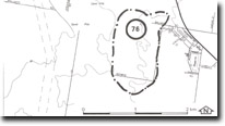 Site 76, Cranbourne Sand type locality |

© State of Victoria (Agriculture Victoria) 1996 - .

This work, Victorian Resources Online, is licensed under a Creative Commons Attribution 4.0 licence. You are free to re-use the work under that licence, on the condition that you credit the State of Victoria (Agriculture Victoria) as author, indicate if changes were made and comply with the other licence terms.
The licence does not apply to ‘branding’ or some ‘images or photographs’ that may be owned by third parties. We ask you to seek prior approval to use images using the VRO feedback form. Access to higher quality images can also be provided on request.
This page was last updated on .