
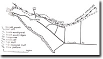
136. Corinella - Corinella Structure
|
This information has been developed from one or more of these publications:
|
Location: | Corinella - 63.473. One kilometre east of the jetty at Corinella. | 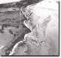 "Ironstone" ridges at Corinella, Site 136 |
| Access: | Corinella Road and walk east from Jamieson Street. | |
| Ownership: | Crown land. | |
| Geology: | The shore platform and beach exposes a contact between ferruginous Baxter Formation and Older Volcanics, the coarse current-bedded structures of the Baxter Formation dipping steeply to the north indicating considerable drag or upwarping of these beds (Thompson, 1974). Jenkin (1962) described projecting ribs of ironstone occurring on the faulted contact between the formations. Thompson (1974) considered the structure to be monoclinal rather than faulted, and suggested the ironstone beds were indurated due to water outflow along the weathered contact at the top of volcanics. The fault/monocline determines the alignment of the coast and the details of shoreline configuration are related to different rates of weathering and erosion of the materials exposed at the contact. | |
| Significance: | State. The site is a clear display of a major geological feature and shows the influence of lithology and structure on shoreline development. The uncertainty about the nature of the structure is of particular significance at the site. | |
| Management: | Class 1. Activities that will damage the site in any way should not be permitted. These include roadworks, excavation, coastal protection structures, and dumping of material on the beach, shore platforms and the adjacent buffers. | |
References: | Jenkin, J.J. (1961). The geology and hydrogeology of the Westernport area. M.Sc. thesis (Unpub.), Dept. of Geol. Univ. of Melb. Thompson, B.R. (1974). The geology and hydrogeology of the Westernport sunklands. Geol. Surv. Rept. 1974/1. McMickan (1977). | |
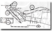 Sites 133, 134, 135 & 136, Corinella area |

© State of Victoria (Agriculture Victoria) 1996 - .

This work, Victorian Resources Online, is licensed under a Creative Commons Attribution 4.0 licence. You are free to re-use the work under that licence, on the condition that you credit the State of Victoria (Agriculture Victoria) as author, indicate if changes were made and comply with the other licence terms.
The licence does not apply to ‘branding’ or some ‘images or photographs’ that may be owned by third parties. We ask you to seek prior approval to use images using the VRO feedback form. Access to higher quality images can also be provided on request.
This page was last updated on .