
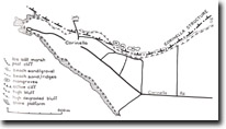
135. Corinella - Raised Beach
|
This information has been developed from one or more of these publications:
|
| Location: | Corinella – 618477. 300 m west of the jetty at Corinella. | 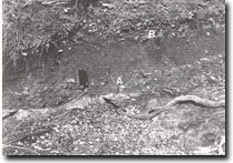 Weathered basalt platform surface (arrowed) overlain by beach gravels and shells (A). At the top is a midden (B). |
| Access: | Corinella Road. | |
| Ownership: | Crown land. | |
| Geomorphology: | A deposit of stratified sediments at the foot of the bluff includes a variety of minor gravel, sand, shell and clay. A section of the material in a wave-cut low cliff includes two distinct horizons containing shells. Jenkin (1961) and McMickan (1977) interpreted the lower shell bed as a former beach built at a sea level one to two metres above present sea level, and the upper bed as a kitchen midden. However, given that the deposit is now being eroded by occasional storm wave action, it is likely that the lower bed simply represents deposition at a time of more vigorous wave action in the past and is not necessarily an emerged or raised beach deposit. | |
| Significance: | State. The site is one of several in Victoria used to interpret Holocene sea level history. It is readily accessible and provides an important field locality for teaching and research in coastal studies. | |
| Management: | Class 1. Activities that will damage the site in any way cannot be permitted. These include roadworks excavation, coastal protection structures, and dumping of material on the slope foot deposits and the adjacent bluffs, cliffs and shore platforms. | |
| References: | Jenkin, J.J. (1961). The geology and hydrogeology of the Westernport area. M.Sc. thesis (unpub.), Dept. of Geol. Univ. of Melb. McMickan (1977). | |
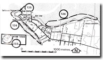 Sites 133, 134, 135 & 136, Corinella area |

© State of Victoria (Agriculture Victoria) 1996 - .

This work, Victorian Resources Online, is licensed under a Creative Commons Attribution 4.0 licence. You are free to re-use the work under that licence, on the condition that you credit the State of Victoria (Agriculture Victoria) as author, indicate if changes were made and comply with the other licence terms.
The licence does not apply to ‘branding’ or some ‘images or photographs’ that may be owned by third parties. We ask you to seek prior approval to use images using the VRO feedback form. Access to higher quality images can also be provided on request.
This page was last updated on .