
173. Churchill Island - Coastal Bluffs
|
This information has been developed from one or more of these publications:
|
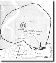
Location: | Woolamai – 550373. 2 km north-west of Newhaven. | 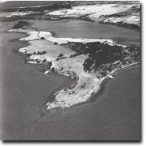 Churchill Island is fringed by low bluffs. Small cliff sectors are shown by arrows. Note the intricate drainage on the tidal flats, Site 173 |
Access: | Churchill Island is linked by a bridge to Phillip Island. Access is from Phillip Island Road and visitors are permitted between 10.00 am to 5.00 pm daily. An admission charge is levied by the National Parks Service. | |
Ownership: | Crown land. | |
Geology/Geomorphology: | Churchill Island consists of weathered Older Volcanics basalt and tuff which crop out around the shoreline of most of the island. There are only three small areas of active marine cliffing and most of the island is bounded by coastal bluffs. In the south, the island is extended by spits and beach ridges of coarse gravel and cobbles. Mangroves are restricted to an area extending for several hundred metres north-west of South Point. East of Grants memorial on the south coast is a terrace of beach gravels 0.5 m above high water mark. The gravel beaches here are only a veneer of stones that lie on a sloping ramp shore platform. Churchill Island is surrounded by a broad expanse of intertidal flat. This is now a low wave energy environment reflected in the dominance of clay-size material on the flats (Marsden and Mallett 1975). The former marine cliffs and abandoned gravel ridges may be interpreted as indicating either a more vigorous wave regime in the past or they may be relict of higher sea level forms. | |
Significance: | Regional. The shorelines illustrate many of the characteristics of the northern coast of Phillip Island. Particular interest centres on those aspects that may be indicative of higher sea levels. | |
Management: | Class 2. Continued management by the National Parks Service as an historic area is consistent with maintaining the significant geomorphological features. Roadworks adjacent to the bridge would disturb the gravel ridges and should be prohibited. Road widening or installation of culverts should not be permitted across this part of the island. | |

© State of Victoria (Agriculture Victoria) 1996 - .

This work, Victorian Resources Online, is licensed under a Creative Commons Attribution 4.0 licence. You are free to re-use the work under that licence, on the condition that you credit the State of Victoria (Agriculture Victoria) as author, indicate if changes were made and comply with the other licence terms.
The licence does not apply to ‘branding’ or some ‘images or photographs’ that may be owned by third parties. We ask you to seek prior approval to use images using the VRO feedback form. Access to higher quality images can also be provided on request.
This page was last updated on .