
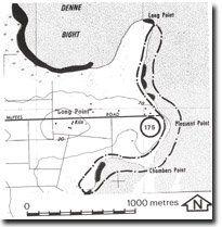
175. Chambers Point to Long Point - Raised Beaches
|
This information has been developed from one or more of these publications:
|
Location: | Woolamai 515373 to Rhyll 50389. The site is a narrow coastal strip on the western shoreline of Swan Bay. | 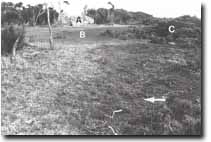 Bluff (A), saltmarsh terrace (B), relict gravel beach (arrowed), mangrove (C) north of Pleasant Point, Site 175. |
| Access: | McFees Road. | |
| Ownership: | Crown land and some private land. | |
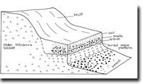
| Geomorphology: | The coastline included in the site is one of low bluffs fringed in the north by mangrove and saltmarsh and in the south by gravel beaches that lie as a veneer over a sloping ramp cut in weathered basalts. At Pleasant Point and to the west of Chambers Point are short sectors of active cliff. Of particular interest north of Pleasant Point is a low terrace of gravel and sand inland of the mangrove and saltmarsh zone and 0.5 m above high water mark. South of Pleasant Point and at Chambers Point is a slightly higher terrace containing rounded small gravels and marine shells. This deposit rests on an eroded basalt surface that appears to be a former higher level shore platform. Inland of this and 500 m south-west of Chambers Point is a distinctive bench up to 50 m wide and 3 to 5 m above present high water mark. | |
| Significance: | State. The site contains several features strongly suggestive of an origin related to a higher Holocene sea level. The features are in close proximity and constitute an important assemblage of emerged coastal forms. No detailed analysis of the age or origin of these features has yet been undertaken. | |
| Management: | Class 1. Further disturbance to the site by any means should be prohibited. The Crown Reserve should be fenced to exclude stock in all parts of the site and drainage or removal of any material should be prohibited. Building of coastal protection structures and boat harbour or launching facilities should not be permitted here. | |
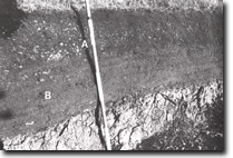 Shell bed (A), stratified gravels (B), eroded basalt platform surface (arrowed), Site 175. |

© State of Victoria (Agriculture Victoria) 1996 - .

This work, Victorian Resources Online, is licensed under a Creative Commons Attribution 4.0 licence. You are free to re-use the work under that licence, on the condition that you credit the State of Victoria (Agriculture Victoria) as author, indicate if changes were made and comply with the other licence terms.
The licence does not apply to ‘branding’ or some ‘images or photographs’ that may be owned by third parties. We ask you to seek prior approval to use images using the VRO feedback form. Access to higher quality images can also be provided on request.
This page was last updated on .