
86. Cardinia - Arcuate Ridge
|
This information has been developed from one or more of these publications:
|
| Location: | Tooradin – 618767. Cardinia Township. | 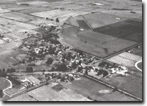 Arcuate sand ridge, Cardinia, Site 86. |
Access: | Ballarto Road. | |
Ownership: | Private land and Crown land. | |
Geology/Geomorphology: | Cardinia township is built on a low sandy ridge that rises five to eight metres above the drained wetlands of the former Dalmore Swamp, part of the Koo-Wee-Rup or Great Swamp. The elevation of the ridge is partly due to depression of the adjacent drained area, as a result of shrinkage and compaction of the peats, but it is also clearly a distinct depositional feature related to sedimentation of the Cardinia Creek. The ridge is composed of coarse and often gravelly and clayey sand and has a well defined concave western margin which resembles an abandoned shoreline. In contrast the eastern edge is less regular with small lobes of sand surrounded by peaty swamp deposits. | |
These lobes may represent old flood crevasse breaches of the ridge. The ridge has the general appearance of a lunette although it was explained by Jenkin (1974) as a former levee deposit of the Cardinia Creek. | ||
Significance: | State. This is one of the two broadly arcuate sand ridges that rise above the drained swamplands. They are morphologically and sedimentologically unique in the study area, and are unusual landforms on a state-wide comparison. Their exact mode of origin has no been investigated in detail. | |
Management: | Class 2. As the ridge provides the safest building sites in the Cardinia area, further subdivision could be allowed. Small barrow pits could be permitted as these provide cross-sections into the ridge materials. | |
References: | Jenkin, J.J. (1962). The geology and underground water resources of the Tooradin area. Dept. of Mines Vict. Underground Water Investigation Report. No. 4 Jenkin, J.J. (1974). The geology of the Mornington Peninsula and Westernport. Geol. Surv. Report. No. 1974/3. | |
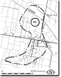 Site 86, arcuate ridge, Cardinia |

© State of Victoria (Agriculture Victoria) 1996 - 2025.

This work, Victorian Resources Online, is licensed under a Creative Commons Attribution 4.0 licence. You are free to re-use the work under that licence, on the condition that you credit the State of Victoria (Agriculture Victoria) as author, indicate if changes were made and comply with the other licence terms.
The licence does not apply to ‘branding’ or some ‘images or photographs’ that may be owned by third parties. We ask you to seek prior approval to use images using the VRO feedback form. Access to higher quality images can also be provided on request.
This page was last updated on 23/11/2018.