
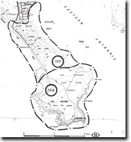
171. Woolamai Beach and Tie-bar
|
This information has been developed from one or more of these publications:
|
Location: | Woolamai – 555323. South-east from Woolamai Waters. | |
Access: | Woolamai Beach Road. | |
Ownership: | Crown land (Cape Woolamai State Faunal Reserve). | |
Geology/Geomorphology: |
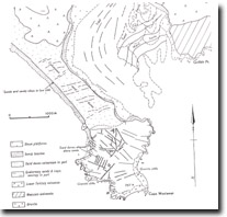
The site includes the tie-bar that links Cape Woolamai to the main body of Phillip Island. The tombolo consists of a basement of basalt and Upper Tertiary sediments regarded by Jenkin (1962, 1974) as equivalents of the Warneet Beds, overlain by siliceous and calcareous sands form the active and partially stabilized dunes of the body of the isthmus. The (1973) study recognised two sets of parabolic dunes – a dominant set moving north-easterly towards Cleeland Bight and a minor set developed on the eastern shore and extending only a short way inland. In detail the dune topography is complex with smaller parabolic ridges superimposed on the larger sets and there are several large basin-shaped deflation hollows. An increase in vegetation on the Bass Strait coast dunes leads to a reduction of sand supply to the beaches of Cleeland Bight and some erosion has recently been noted on those beaches (Eric Bird, pers. Comm.). | |
Significance: | National. The tie-bar or tombolo is accorded the same significance status as Cape Woolamai as it is regarded as an integral part of the tombolo complex. | |
Management: | Class 2. Restriction of pedestrian and vehicular traffic to well defined routes is necessary to avoid major disturbance to dune topography and vegetation. Relocation of the road to the surf lifesaving club, via an inland route that follows the dune topography, would be acceptable if it was considered impossible to maintain the present alignment. However, it is essential to recognise that the dunes of the tombolo are intermittently active features, and it must be anticipated that episodes of substantial sand movement will occur. | |
References: | Jenkin, J.J. (1962). The geology and underground water resources of the Tooradin area. Dept. of Mines Vict. Underground Water Investigation Report No. 4. Teh, Tiong Sa. (1973). The orientation of parabolic dunes at Cape Woolamai, Victoria, Aust. Ilmu Alam, Bil. 2. | |
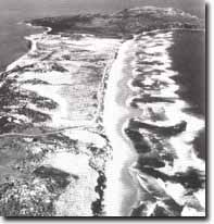 The tombolo complex of Cape Woolamai includes the dune capped granitic upland of Cape Woolamai and a sand covered isthmus 2.5 km long. Basaltic and sedimentary rocks underlie the isthmus. Note the strong surf and numerous rip currents on the Bass Strait shoreline and the contrast with the sheltered coast of The Narrows (upper left), Site 171 |

© State of Victoria (Agriculture Victoria) 1996 - .

This work, Victorian Resources Online, is licensed under a Creative Commons Attribution 4.0 licence. You are free to re-use the work under that licence, on the condition that you credit the State of Victoria (Agriculture Victoria) as author, indicate if changes were made and comply with the other licence terms.
The licence does not apply to ‘branding’ or some ‘images or photographs’ that may be owned by third parties. We ask you to seek prior approval to use images using the VRO feedback form. Access to higher quality images can also be provided on request.
This page was last updated on .