
10. Bunyip River - High Level Terraces and Flood Plain
|
This information has been developed from one or more of these publications:
|
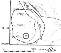
| Location: | Spion Kopje – 905940. Twelve kilometres north Bunyip | 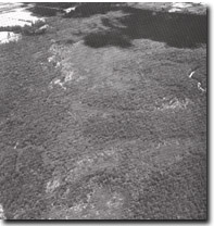 Swampy higher level terraces of the Bunyip River |
Access: | Ryson Creek Track via Gentle Annie Road. | |
Ownership: | Crown Land and private land. | |
Geology/Geomorphology: | The Bunyip River is flanked by alluvial fans and terrace deposits as it emerges from the ranges to the north. The complexity of old depositional terrain and the reduction of river gradient have combined to produce areas of impeded drainage, characterised by waterlogged and peaty soils, and small open ponds and swamps. On the western side of the valley, these wetlands lie above the present flood plain. | |
Significance: | Regional. The site illustrates a prior stage in the development of the valley of the Bunyip River. The relationship between vegetation patterns and drainage is clearly demonstrated. | |
Management: | Class 1. The value of the site depends upon retaining the present patterns of vegetation and drainage. Clearing or artificial drainage of the area should be prohibited. | |

© State of Victoria (Agriculture Victoria) 1996 - .

This work, Victorian Resources Online, is licensed under a Creative Commons Attribution 4.0 licence. You are free to re-use the work under that licence, on the condition that you credit the State of Victoria (Agriculture Victoria) as author, indicate if changes were made and comply with the other licence terms.
The licence does not apply to ‘branding’ or some ‘images or photographs’ that may be owned by third parties. We ask you to seek prior approval to use images using the VRO feedback form. Access to higher quality images can also be provided on request.
This page was last updated on .