
219. Blue Gum Point to Spit Point
|
This information has been developed from one or more of these publications:
|
| Location: | Palmer - 692540 to 658523. South-eastern sector of coastline extending from near Spit Point (formerly Sandy Point) on the extreme south-east of French Island, west along the shoreline to 1 km north-west of Blue Gum Point. | 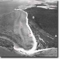 Recurving spits at Spit Point (foreground). Arrow shows Blue Gum Point. A and B mark the position of the Pleistocene bluff. Note the complex ridge and lagoon system that lies seaward of the bluff, Site 219. |
Access: | Via a sandy vehicle track from the Recreation Camp to Albions then continue along track to the north of Spit Point. | |
Ownership: | Crown land - Coastal Reserve and State Park. | |
Geomorphology: | The site consists of sandy beaches at the seaward boundary of an extensive system of older coastal ridges and salt marsh. The landward boundary of the site is an old sea cliff, now a bluff, which represents the position of the Pleistocene shoreline of this area approximately 120,000 years ago. At both points, actively prograding sandy accumulation features occur in the form of a looped bar at Blue Gum Point, and a recurved spit at Spit Point. The preserved configuration of the older coastal ridges between Spit Point and Blue Gum Point indicates the feature may be a truncated cuspate foreland (Bird 1977) | |
Significance: | State. The site is one in which a complex interplay of geomorphological processes has occurred. Core samples taken through swales at Spit Point by Kraemers (1980) indicate a sequential deposition of salt marsh and freshwater peat that occurred prior to sandy deposition. This infers that the older coastal ridges of the area may be cheniers. The ridge deposits of the Spit Point area are separated from the bluff-line by an unusually broad band of salt marsh. Erosion of the salt marsh along the eastern shoreline of Spit Point is prominent with chenier formation occurring at the outer edge of the salt marsh. In marked contrast, the southern shoreline between Blue Gum and Spit Points is prograding with a succession of low sinuous ridges stabilised by the grass, Ammophila. | |
The mobile accumulation forms developed in the coastal sector of the site are undergoing continual modification by the action of wind and waves and constitute an excellent site for the study of sandy shoreline progradation and landform development in Westernport Bay. It is essential to note that excellent stereo aerial photograph coverage of this area dating from 1932 is readily available, while aerial oblique photography of the area from 1960 provides a valuable supplement to the higher altitude coverage. Investigation of early maps indicates that Spit Point has grown towards the south-east, with a marked extension in this direction being seen in aerial photographs of the area taken in 1939 and 1973 (Bird and Barson 1975). | ||
Management: | Class 1. The building of any structures which would interfere with sediment flows into and out of the area, would have a detrimental effect on the development of the sandy accumulation forms. To ensure adequate sediment input it is recommended that, in the coastal sector between Palmer Point and Freeman Point no groynes, jetties or breakwaters be constructed. The natural erosion of the Baxter Formation and basalts exposed along the coast in this area provides a major part of the sedimentary supply to both Blue Gum and Spit Points, and it is therefore also recommended that no measures be taken to prevent the continued erosion of these cliffs and coastal deposits. | |

© State of Victoria (Agriculture Victoria) 1996 - .

This work, Victorian Resources Online, is licensed under a Creative Commons Attribution 4.0 licence. You are free to re-use the work under that licence, on the condition that you credit the State of Victoria (Agriculture Victoria) as author, indicate if changes were made and comply with the other licence terms.
The licence does not apply to ‘branding’ or some ‘images or photographs’ that may be owned by third parties. We ask you to seek prior approval to use images using the VRO feedback form. Access to higher quality images can also be provided on request.
This page was last updated on .