
142. Bass River - Delta and Floodplain
|
This information has been developed from one or more of these publications:
|
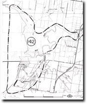
Location: | Corinella – 640380. The site extends for 3 km west from the township of Bass. | 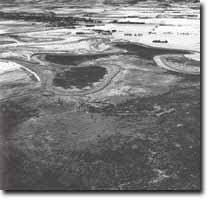 Floodplain and delta of the Bass River, Site 142 |
Access: | Bass Landing Road. | |
Ownership: | Mainly Crown land and some private land. | |
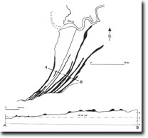
Geology/Geomorphology: | This large site includes the lower floodplain, delta, and intertidal sandy zone of the Bass River. The embayment between Kennedy Point and San Remo peninsula is filled with a complex of Quaternary sediments deposited by fluviatile, paludal, deltaic, shoreline, and intertidal processes. These represent the sequence of valley formation and infilling by the Bass River and by marine incursions in the Late Pleistocene and Holocene. The emerged deltaic zone is a narrow and crescent-shaped concave landwards, but there is a broader intertidal and subtidal delta area that extends for several hundred metres offshore. The morphology and sedimentology of the area have been studied in some detail and summarized by Marsden and Mallett (1975). They argue that several features of this area – notably the parallel sand ridges that lie south of the river – are evidence of Holocene sea levels up to 1.5 m above the present level. The configuration of the abandoned and active meanders of the river below the township of Bass is a clear indication of the strong tidal flow in the lower channel. The amplitude is several times larger than the river meanders east of bass. The introduction and spread of Spartina on intertidal land at the mouth of the Bass River and in the abandoned meanders is of particular interest as this is the major occurrence of this grass in Westernport. | |
Significance: | National. The site includes the point of largest natural sediment influx into the bay and is one of the most closely investigated quaternary sedimentological and geomorphological sites in Westernport. The delta is a feature of considerable complexity and provide opportunity for continuing research into deltaic and intertidal dynamics. The interpretation of Holocene sea level movement here by Marsden and Mallett (1975), differs from that advanced by Miles (1976) for areas further north in Westernport (see Site 115 Pioneer Bay). | |
Management: | Class 1. Large scale drainage or land reclamation schemes or dredging and enlarging of the outlet of the Bass River should not be permitted. Other land use proposals that involved reshaping or covering the terrain of the delta, floodplain and beach ridges on the south of the Bass River should not be permitted. This restriction should apply also to the abandoned meanders and saltmarsh north of the river. | |
References: | Jenkin, J.J. (1962). Underground water resources of Phillip Island. Dept. of Mines Vict. Underground Water Investigation, Report No. 3. Power. (1971). Tickell, S.J. (1971). The geology of the Bass River area. B.Sc. Hons. thesis (unpub.) Dept. of Geol. Univ. of Melb. Marsden, M.A.H. and Mallett, C.W. (1975). Quaternary evolution, morphology and sediment distribution, Westernport Bay, Victoria. Proc. Roy. Soc. Vict. Vol. 87 (1) 107-137. | |
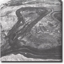 Abandoned tidal meanders filled with Spartina towsendii (A), and point bar ridges (arrowed), Bass River delta, Site 142 |

© State of Victoria (Agriculture Victoria) 1996 - .

This work, Victorian Resources Online, is licensed under a Creative Commons Attribution 4.0 licence. You are free to re-use the work under that licence, on the condition that you credit the State of Victoria (Agriculture Victoria) as author, indicate if changes were made and comply with the other licence terms.
The licence does not apply to ‘branding’ or some ‘images or photographs’ that may be owned by third parties. We ask you to seek prior approval to use images using the VRO feedback form. Access to higher quality images can also be provided on request.
This page was last updated on .