
211. The Anchorage
|
This information has been developed from one or more of these publications:
Geological heritage sites, including sites of geomorphological interest and volcanic heritage sites, are under regular revision by the Geological Society of Australia, especially in the assessment of significance and values. Reference should be made to the most recent reports. See the Earth Science Heritage section of the Geological Society of Australia website (external link) for details of geological heritage reports, and a bibliography. |
Location: | Rhyll - 505487. 1 km south of Tankerton. | 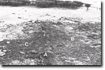 Ironstone (A) at the plane of contact between Older Volcanics basalt (B) and Mesozoic (C), The Anchorage, Site 211. |
Access: | The Anchorage Road and track across private land. | |
Ownership: | Crown land. | |
Geology/Geomorphology: | Within a relatively confined area occur a number of geological and geomorphological features of particular interest. The base of a vegetated bluff in Older Volcanics is being re-activated by wave action along a 100 m sector where mangroves have been removed to provide boat access. Exposed at the base of the bluff in this area is basaltic clay which retain spheroidal weathering features. At the site of direct vehicular access to the coastline, an eroding terrace of salt marsh peats, sand and ferruginous gravel overlies a former shore in basalt. Removal of a large number of mangroves in this area for the construction of a launching ramp appears to have initiated the erosion. A low, active sea cliff in Lower Cretaceous strata with prominent vertical jointing and containing silicified woody fragments and small lenses of intraformational conglomerate, is fronted by a broad shore platform. To the west of this cliff is the best exposure on French Island of the contact zone between Lower Cretaceous sandstones and Older Volcanics. The contact is represented by a ferruginous, indurated sandstone which was interpreted by Jenkin (1962) as a fault. | |
Significance: | State. The presence of the contact zone between Tertiary and Mesozoic formations is of particular geological significance. It is the only well preserved and easily observed contact exposed on French Island and one of the best in the Westernport catchment. The site demonstrates the effects of mangrove removal on shoreline stability, and is of interest for the study of dynamic morphology of an actively eroding shoreline. | |
Management: | Class 1. To maintain the dynamic morphology of the area no modifications to the present shoreline should be made as these could lead to a change in the sediment regime of the area. Such a change could contribute to the masking of the fault contact zone by drifting sand. As the erosion observed along this sector of coastline does not pose a threat to private property, it is recommended that no coastal protection works be undertaken. | |
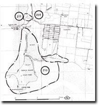 Sites 209 to 211, Tankerton and Tortoise Head area |

© State of Victoria (Agriculture Victoria) 1996 - .

This work, Victorian Resources Online, is licensed under a Creative Commons Attribution 4.0 licence. You are free to re-use the work under that licence, on the condition that you credit the State of Victoria (Agriculture Victoria) as author, indicate if changes were made and comply with the other licence terms.
The licence does not apply to ‘branding’ or some ‘images or photographs’ that may be owned by third parties. We ask you to seek prior approval to use images using the VRO feedback form. Access to higher quality images can also be provided on request.
This page was last updated on .