
99. Heath Hill - Heath Hill Fault Scarp
|
This information has been developed from one or more of these publications:
|
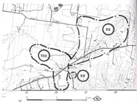
| Location: | Catani - 873673. Area extending three kilometres north of Heath Hill. | |
Access: | Western Port Road, South Yanathan Road. | |
Ownership: | Private land and some Crown Land. | |
Geology/Geomorphology: | The eastern margin of the Koo-Wee-Rup Plain is marked by an abrupt rise trending northeast-southwest. This rise extends from west of Drouin towards the coast at Grantville and forms the western margin of the elevated block-faulted terrain of the South Gippsland Hills. The principal control of relief is the Heath Hill Fault which is of late Pliocene or early Pleistocene age. In the Heath hill area, uplift of up to 150 metres to the east is indicated by the relative elevations of Older Volcanics on both sides of the fault. North of the Lang Lang River at Heath Hill the scarp is prominent, rising almost 100 metres above the flood plain. The Lang Lang River has cut a deep valley into the scarp and the elevated block exposing the Mesozoic rocks in the valley walls. The lower part of the valley has subsequently become filled with floodplain deposits. Lower slope material on the west of the fault scarp were mapped by Jenkin (1962) as Grantville Gravels - alluvial fan materials developed from scarp erosion and retreat. Thompson (1974) and Spencer-Jones et al. (1975) regarded these as an upper unit of the Baxter Formation and not resulting from the process described by Jenkin (1962, 1974). The materials are exposed in a small quarry beside Wafes Road. The distribution of Older Volcanics and Baxter Sandstone, and the position of the trace of the Heath Hill Fault has been shown differently on at least three published maps (Jenkin, 1962; Mines Department, 1971); Thompson 1974). | |
Significance: | State. The area includes physiographical and geological features important in determining the stratigraphy and structure of the eastern part of the Westernport catchment. The different interpretations of the geology of the area (referred to above) are an illustration of this importance. | |
Management: | Class 3. Quarrying and roadworks could be permitted as these would provide new geological sections. Continuation of current land use is compatible with maintaining the significant features of the site, but highly intensive forms of land use, e.g. small allotment subdivision, should not be permitted as these would mask the form of the significant terrain features. | |
References: | Jenkin, J.J. , 1962. The geology and hydrology of the Western Port area. Dept. of Mines, Vict Underground Water Investigation Rept. No. 5. Jenkin, J.J., 1974. The geology of the Mornington Peninsula and Westernport. Geol. Surv. Rept. No. 1974/3. Thompson, B. R. ,1974. The geology and hydrology of the Western Port sunklands. Geol. Surv. Rept. 1974/1. Spencer-Jones, D., Marsden, M.A.H., Barton, C.M. & Carrillo-Rivera, J.J., 1975. Geology of the Western Port sunkland. Proc. Roy. soc. Vict. (87) 1&2, 43-68. | |


© State of Victoria (Agriculture Victoria) 1996 - 2025.

This work, Victorian Resources Online, is licensed under a Creative Commons Attribution 4.0 licence. You are free to re-use the work under that licence, on the condition that you credit the State of Victoria (Agriculture Victoria) as author, indicate if changes were made and comply with the other licence terms.
The licence does not apply to ‘branding’ or some ‘images or photographs’ that may be owned by third parties. We ask you to seek prior approval to use images using the VRO feedback form. Access to higher quality images can also be provided on request.
This page was last updated on 23/11/2018.