
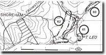
62. Point Leo - East Creek Dry Valley
|
This information has been developed from one or more of these publications:
|
| Location: | Flinders – 321453. Fifty metres south of the breakwater at point Leo. | |
Access: | Walk from Point Leo breakwater. | |
Ownership: | Crown Land. | |
Geology/Geomorphology: | An abandoned cobble beach lies 0.5 to 1.0 metres above high water mark. The beach materials include rounded basalt, and siliceous and ferruginous sandstone cobbles set in cemented sandy matrix. | |
Significance: | State. The site indicates that a different wave environment and/or a higher sea level occurred in earlier Holocene times at point Leo. | |
Management: | Class 1. No construction or roadwork activity of any kind that would obscure the beach section should be permitted in the area of the site. | |

© State of Victoria (Agriculture Victoria) 1996 - .

This work, Victorian Resources Online, is licensed under a Creative Commons Attribution 4.0 licence. You are free to re-use the work under that licence, on the condition that you credit the State of Victoria (Agriculture Victoria) as author, indicate if changes were made and comply with the other licence terms.
The licence does not apply to ‘branding’ or some ‘images or photographs’ that may be owned by third parties. We ask you to seek prior approval to use images using the VRO feedback form. Access to higher quality images can also be provided on request.
This page was last updated on .