
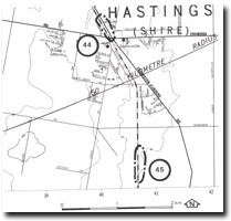
45. Tyabb - Baxter Formation
|
This information has been developed from one or more of these publications:
|
| Location: | Baxter – 447651. Stony Point railway line two kilometres south of Somerville. | |
| Access: | From Bungower Road railway crossing. | |
| Ownership: | Crown Land. | |
| Geology: | The cutting exposes weathered Baxter Formation sediments. | |
| Significance: | Local. This is one of the more extensive inland exposures of the Baxter Formation in the Mornington Peninsula section of the Western Port Bay catchment. | |
| Management: | Class 2. The sides of the cutting should be kept clear to maintain the exposure. | |

© State of Victoria (Agriculture Victoria) 1996 - .

This work, Victorian Resources Online, is licensed under a Creative Commons Attribution 4.0 licence. You are free to re-use the work under that licence, on the condition that you credit the State of Victoria (Agriculture Victoria) as author, indicate if changes were made and comply with the other licence terms.
The licence does not apply to ‘branding’ or some ‘images or photographs’ that may be owned by third parties. We ask you to seek prior approval to use images using the VRO feedback form. Access to higher quality images can also be provided on request.
This page was last updated on .