
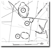
43. Pearcedale - Inter-dune Swamp
|
This information has been developed from one or more of these publications:
|
| Location: | Baxter – 448665. Three kilometres south of Pearcedale. | |
| Access: | Queens Road. | |
| Ownership: | Private land. | |
| Geomorphology: | An area of swamp and open water enclosed by low dune ridges of Cranbourne Sand. The base of the deflation hollow may be Baxter Sandstone. A smaller dry depression lies 150 metres south-east of the main swamp. | |
| Significance: | Local. This is the least disturbed freshwater wetland in the Mornington Peninsula section of the Westernport Bay catchment. It is representative of a widespread terrain type in the area before European settlement. | |
| Management: | Class 1. Drainage, clearing or artificial filling of the area of the site should not be permitted. | |

© State of Victoria (Agriculture Victoria) 1996 - .

This work, Victorian Resources Online, is licensed under a Creative Commons Attribution 4.0 licence. You are free to re-use the work under that licence, on the condition that you credit the State of Victoria (Agriculture Victoria) as author, indicate if changes were made and comply with the other licence terms.
The licence does not apply to ‘branding’ or some ‘images or photographs’ that may be owned by third parties. We ask you to seek prior approval to use images using the VRO feedback form. Access to higher quality images can also be provided on request.
This page was last updated on .