
33. Bunyip River Bridge - Terraces and Abandoned Channels
|
This information has been developed from one or more of these publications:
|
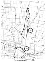
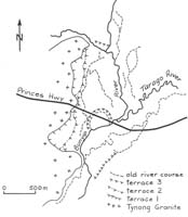
| Location: | Tonimbuk - 898837 to Labertouche - 906856. Bunyip River Valley south of the junction with Cannibal Creek and the Tarago River. | 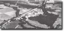 Terraces and abandoned higher level meander (A) of the Bunyip River. |
Access: | Princes Highway and A'Beckett Road. | |
Ownership: | Crown Land (Public Land Water Frontage Reserve) and private land. | |
Geomorphology: | This sector of the Bunyip River lies immediately upstream of the Main Drain, and has become incised deeply into the flood plain that was developed prior to drainage of the swamps to the south. The recent incision phase has left a paired terrace system adjacent to the channel. Depressions on the terrace surface are traces of former channels. The configuration and depth of these older channels indicates three stages of terrace incision. | |
Significance: | State. The site is of considerable interest for the study of the chronology of river channel changes since European settlement in the area. | |
Management: | Class 2. Extensive building construction and artificial reclamation or filling of the depressions on the terrace surface should not be permitted. | |

© State of Victoria (Agriculture Victoria) 1996 - .

This work, Victorian Resources Online, is licensed under a Creative Commons Attribution 4.0 licence. You are free to re-use the work under that licence, on the condition that you credit the State of Victoria (Agriculture Victoria) as author, indicate if changes were made and comply with the other licence terms.
The licence does not apply to ‘branding’ or some ‘images or photographs’ that may be owned by third parties. We ask you to seek prior approval to use images using the VRO feedback form. Access to higher quality images can also be provided on request.
This page was last updated on .