
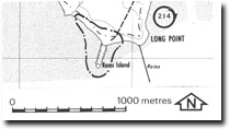
214. Rams Island - Tombolo
|
This information has been developed from one or more of these publications:
|
| Location: | Rhyll - 557459. 6 km east of Tortoise Head. | |
Access: | Walk from Long Point Road. | |
Ownership: | Crown land. | |
Geology/Geomorphology: | Rams Island is a small basalt knob surrounded by gravel beaches. A gravel ridge or swashway about 200 m long connects the island to French Island. | |
Significance: | Local. The island is a very good example of a small tombolo. | |
Management: | Class 1. No removal of gravel or sand from the site should be permitted. No artificial coastal structures should be built in the area of the site. | |

© State of Victoria (Agriculture Victoria) 1996 - .

This work, Victorian Resources Online, is licensed under a Creative Commons Attribution 4.0 licence. You are free to re-use the work under that licence, on the condition that you credit the State of Victoria (Agriculture Victoria) as author, indicate if changes were made and comply with the other licence terms.
The licence does not apply to ‘branding’ or some ‘images or photographs’ that may be owned by third parties. We ask you to seek prior approval to use images using the VRO feedback form. Access to higher quality images can also be provided on request.
This page was last updated on .