
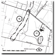
17. Pakenham - Silurian Outcrop in Quarry
|
This information has been developed from one or more of these publications:
|
| Location: | Pakenham – 656846. Five hundred metres west of McGregor Road at Pakenham. | |
| Access: | Off McGregor Road. | |
| Ownership: | Private Land. This small abandoned quarry provides an exposure of the steeply dipping Silurian sandstone and mudstone that underlies the Pakenham – Berwick area. | |
| Significance: | Local. This is a clear exposure of the bedrock of this part of the catchment. | |
| Management: | Class 3. Any reclamation or filling of the quarry should be designed to maintain some exposures of the Silurian rocks on at least one of the upper faces. | |

© State of Victoria (Agriculture Victoria) 1996 - .

This work, Victorian Resources Online, is licensed under a Creative Commons Attribution 4.0 licence. You are free to re-use the work under that licence, on the condition that you credit the State of Victoria (Agriculture Victoria) as author, indicate if changes were made and comply with the other licence terms.
The licence does not apply to ‘branding’ or some ‘images or photographs’ that may be owned by third parties. We ask you to seek prior approval to use images using the VRO feedback form. Access to higher quality images can also be provided on request.
This page was last updated on .