
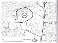
158. Loch - McTaggart Falls
|
This information has been developed from one or more of these publications:
|
| Location: | Jeetho - 851496. Four kilometres south-south-west of Loch. | 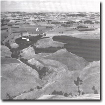 Undissected plateau area (A) at Anderson Hill. Arrows show gorge at edge of plateau. |
Access: | Anderson Hill road. | |
Ownership: | Private land. | |
Geology/ Geomorphology: | The area adjacent to Anderson Hill is a plateau averaging 250 metres above sea level. It is one of the largest of the elevated planar areas in the Strzelecki Ranges and provides a contrasting topography to the typically deeply dissected and 'all slopes' terrain of the south-eastern part of the Western port catchment. The several small streams that drain this area attain abrupt changes in gradient at the plateau margin and on the western side flow in Mesozoic bedrock channels. At this site, the stream has developed a 200 metre series of steep cascades which terminate as a 20 metre vertical waterfall. The Mesozoic rocks are predominantly sandstones with intraformational or slump conglomerates. They dip gently to the south-east and are strongly sheared. Stream potholes have developed along the lines of the shear planes. | |
Significance: | State. This is the major inland valley bedrock exposure. It is an unusually steep valley sector and the waterfall and cascade development on Mesozoic rocks is unique in the study area. It is one of the few such gorge sectors on Mesozoic rocks in Victoria. | |
Management: | Class 1. Reservoir construction, quarrying or any form of water control of the small catchment should be prohibited. An access pathway is needed to the site from a public road and the site should be purchase from private landholdings for public ownership. | |
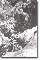 Twenty-metre high falls and gorge at the edge of Anderson Hill plateau. |

© State of Victoria (Agriculture Victoria) 1996 - .

This work, Victorian Resources Online, is licensed under a Creative Commons Attribution 4.0 licence. You are free to re-use the work under that licence, on the condition that you credit the State of Victoria (Agriculture Victoria) as author, indicate if changes were made and comply with the other licence terms.
The licence does not apply to ‘branding’ or some ‘images or photographs’ that may be owned by third parties. We ask you to seek prior approval to use images using the VRO feedback form. Access to higher quality images can also be provided on request.
This page was last updated on .