
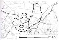
154. Glen Forbes - Bass River Terraces
|
This information has been developed from one or more of these publications:
|
| Location: | Grantville - 723424. Bass River valley adjacent to the Glen Forbes bridge. | 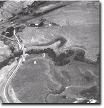 Upper terrace (A) and lower terrace (B) of the Bass River valley at Glen Forbes. Abandoned channels on the terraces are shown by arrows. |
Access: | Dalyston to Glenn Forbes road. | |
Ownership: | Crown Land (Public Land Water Frontage Reserve) and private land. | |
Geology/ Geomorphology: | The western valley slope of the Bass River at Glen Forbes is cut into Tertiary sediments and at river level a 1.5 metre thick sequence of lignite and shaley lignite beds is exposed. These seams were first noted by Stirling (1892). The Bass valley flood plain is a major landform unit in the Western port catchment. The plain consists essentially of two sets of alluvial terraces, the highest and most extensive terrace being eight to ten metres above present mean river level and lower terrace being five to six metres above river level (Brennan 1972). The lower terrace is narrow and parallels the present river channel and on the terrace surface are a number of cut-off meander bends. | |
Significance: | State. The Bass valley terraces are amongst the most distinctive in Victoria. They provide substantial evidence relating to the Late Quaternary history of the south-eastern part of the Western Port catchment. | |
Management: | Class 2. Continuation of the present rural land use is consistent with maintaining the significant features of the site. Extensive excavation of the material of the lower terraces should not be permitted. | |
References: | Brennan, I.D., 1972. Quaternary studies of two Western port environments. B.Sc. (Hons) thesis (unpub.) Dept. of Geology Univ. of Melb. | |

© State of Victoria (Agriculture Victoria) 1996 - .

This work, Victorian Resources Online, is licensed under a Creative Commons Attribution 4.0 licence. You are free to re-use the work under that licence, on the condition that you credit the State of Victoria (Agriculture Victoria) as author, indicate if changes were made and comply with the other licence terms.
The licence does not apply to ‘branding’ or some ‘images or photographs’ that may be owned by third parties. We ask you to seek prior approval to use images using the VRO feedback form. Access to higher quality images can also be provided on request.
This page was last updated on .