
130. Poowong - Cruikston Dyke
|
This information has been developed from one or more of these publications:
|
| Location: | Poowong - 960533. Four kilometres south-east of Poowong. | 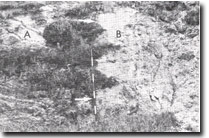 Cruikston Dyke (A) intruding Strzelecki Group sediments (B). Arrow shows contact. |
Access: | Poowong to Ranceby road. | |
Ownership: | Crown Land and private land. | |
Geology: | A small body of intrusive igneous rock is exposed in the road cuttings at the site. The rock was described by Stirling (1892, 1899) as an olivine gabbro and named the Cruikston Dyke. Edwards (1934) described the material as analcite-olivine-dolerite. The intrusion trends north-west to south-west across the road and the cutting on the north of the road shows the contact between the dyke and the enclosing Mesozoic sediments. | |
Significance: | State. This is one of the largest dykes in the study area and is of different composition and texture from most other lower Tertiary intrusions in Victoria. | |
Management: | Class 2. The road cuttings exposing the dyke rock should not be artificially stabilised or vegetated as this would obscure the exposure of the dyke rock and enclosing rocks. | |
References: | Stirling. J., 1892. Reports on the Victorian coalfields, 1. Spec Rept. Coalfields, Geol. Surv. Vict. 1. Stirling. J., 1899. Progress report on survey of Quarter Sheet No. 2, Gippsland Carbonaceous area. Spec. Rept. Coalfields, Vict. No. 2. Edwards, A.B., 1934. Tertiary dykes and volcanic necks of South Gippsland, Victoria. Proc. Roy. Soc. Vic. 47(1) 112-132. | |

© State of Victoria (Agriculture Victoria) 1996 - .

This work, Victorian Resources Online, is licensed under a Creative Commons Attribution 4.0 licence. You are free to re-use the work under that licence, on the condition that you credit the State of Victoria (Agriculture Victoria) as author, indicate if changes were made and comply with the other licence terms.
The licence does not apply to ‘branding’ or some ‘images or photographs’ that may be owned by third parties. We ask you to seek prior approval to use images using the VRO feedback form. Access to higher quality images can also be provided on request.
This page was last updated on .