
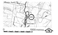
128. Poowong - Gabbroic Dyke
|
This information has been developed from one or more of these publications:
|
| Location: | Poowong - 923568. One kilometre north of Poowong. | 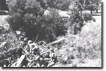 Small quarry exposing gabbroic dyke is now concealed by rubbish. |
Access: | Poowong - Drouin Road. | |
Ownership: | Private land and Crown Land. | |
Geology: | The road cutting exposes dipping weathered Mesozoic sediments, mainly mudstones, and a 15 centimetre coal layer. Samples from a coarse textured intrusive rock that outcrops on private land 200 metres north of the water tower have been described as olivine gabbro and the rock dated at 85.5 million years old (Bowen 1974). This rock does not outcrop in the road cuttings. | |
Significance: | State. The dyke rock is one of the oldest dated in the Gippsland region and is Late Cretaceous in age. Dykes of this composition and texture are rare in Victoria and this is the only one that has been noted in the study area. | |
Management: | Class 2. Changes in land use will not alter the significance of the Mesozoic sedimentary rocks in the road cuttings. The dyke rock is exposed in a small disused quarry on private land and it is largely concealed by water in the quarry and by material deliberately placed to fill the hole. It is recommended that no further filling of the site be permitted or the site of the outcrop will be totally obscured. | |
References: | Bowen (1974). Carey (1979). | |

© State of Victoria (Agriculture Victoria) 1996 - .

This work, Victorian Resources Online, is licensed under a Creative Commons Attribution 4.0 licence. You are free to re-use the work under that licence, on the condition that you credit the State of Victoria (Agriculture Victoria) as author, indicate if changes were made and comply with the other licence terms.
The licence does not apply to ‘branding’ or some ‘images or photographs’ that may be owned by third parties. We ask you to seek prior approval to use images using the VRO feedback form. Access to higher quality images can also be provided on request.
This page was last updated on .