
116. The Gurdies - Williams Gravel Pit (Tertiary Gravels)
|
This information has been developed from one or more of these publications:
|
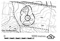
| Location: | Lang Lang - 768524. Two kilometres north-east of The Gurdies. | |
Access: | Peacock Road. | |
Ownership: | Private land. | |
Geology: | The site lies on the Heath Hill Fault scarp and includes several disused quarries exposing poorly sorted cross-bedded gravels, sands and clays. These were interpreted by Jenkin (1962) as alluvial fan deposits and he nominated the site as the type locality of the Grantville Gravels, a new formation he proposed to account for the widespread distribution of these materials along the escarpment. Tickell (1971) re-interpreted the site and suggested that the gravels belonged to the Baxter Formation as the outcrops were continuous with similar lithologies on the upthrown (eastern) side of the Heath Hill Fault. This interpretation received support from Thompson (1974) and Spencer-Jones et al (1975). | |
Significance: | State. The site is an important illustration of different stratigraphical interpretations of a sedimentary deposit. | |
Management: | Class 3. The deposits are extensive and further quarrying would assist interpretation by providing new stratigraphic sections. As the quarries are not being worked, the quality of display of outcrop is deteriorating due to regrowth and slumping. The general principles of quarry management outlined should be referred to. | |
References: | Jenkin, J.J. , 1962. The geology and hydrology of the Western Port area. Dept. of Mines, Vict Underground Water Investigation Rept. No. 5. Tickell, S.J., 1971. The geology of the Bass River Area. B.Sc. Hons thesis (unpub.) Dept. of Geol. Univ. of Melb. Thompson, B. R. ,1974. The geology and hydrology of the Western Port sunklands. Geol. Surv. Rept. 1974/1. Spencer-Jones, D., Marsden, M.A.H., Barton, C.M. & Carrillo-Rivera, J.J., 1975. Geology of the Western Port sunkland. Proc. Roy. soc. Vict. (87) 1&2, 43-68. | |

© State of Victoria (Agriculture Victoria) 1996 - .

This work, Victorian Resources Online, is licensed under a Creative Commons Attribution 4.0 licence. You are free to re-use the work under that licence, on the condition that you credit the State of Victoria (Agriculture Victoria) as author, indicate if changes were made and comply with the other licence terms.
The licence does not apply to ‘branding’ or some ‘images or photographs’ that may be owned by third parties. We ask you to seek prior approval to use images using the VRO feedback form. Access to higher quality images can also be provided on request.
This page was last updated on .