
114. Bass Highway - Old Sea Cliff
|
This information has been developed from one or more of these publications:
|
| Location: | Lang Lang - 723573. Six kilometres south of Lang Lang. | 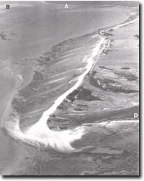 The multiple recurving spits that comprise Stockyard point. Also shown are Lang Lang delta (A), tidal watershed (B), Red bluff (C), part of Pioneer Bay (D). |
Access: | Bass Highway. | |
Ownership: | Mainly private land and some Crown Land. | |
Geology/Geomorphology: | The ridge of Baxter Formation sediments that extends east from Red Bluff has a distinct erosion escarpment on the southern side 15 metres high. The escarpment is crossed by the Bass Highway. The escarpment is a former marine cliff developed prior to the accumulation of Stockyard point and the sedimentary fill in Pioneer Bay. It represents an interglacial sea level several metres above that of the present. | |
Significance: | Regional. The site illustrates a relief form developed at different sea levels from the present and is one of several such localities around Westernport Bay. | |
Management: | Class 3. Changes in land use are not likely to alter the significance of the feature. |

© State of Victoria (Agriculture Victoria) 1996 - .

This work, Victorian Resources Online, is licensed under a Creative Commons Attribution 4.0 licence. You are free to re-use the work under that licence, on the condition that you credit the State of Victoria (Agriculture Victoria) as author, indicate if changes were made and comply with the other licence terms.
The licence does not apply to ‘branding’ or some ‘images or photographs’ that may be owned by third parties. We ask you to seek prior approval to use images using the VRO feedback form. Access to higher quality images can also be provided on request.
This page was last updated on .