
113. Stockyard Point - Cuspate Foreland
|
This information has been developed from one or more of these publications:
|
| Location: | Lang Lang - 703557. Three kilometres south of Lang Lang Beach. | 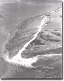 The multiple recurving spits that comprise Stockyard point. Also shown are Lang Lang delta (A), tidal watershed (B), Red bluff (C), part of Pioneer Bay (D). |
Access: | Jetty Lane. | |
Ownership: | Mainly private land with some Crown Land. | |
Geomorphology: | Stockyard Point is a sandy foreland built by accretion of a succession or recurving spits and beach ridges. The foreland has grown to the south with its base or proximal end against the former marine cliff south of Red Bluff. At least 10 major sets of sandy ridges are evident in the growth of the foreland, each major and minor ridge being separated by a swampy depression or swale. The distal or active end of the foreland is a recurving sand spit that advances eastward into Pioneer Bay and encloses a sheltered zone allowing the growth of mangroves and salt marsh. The sediment for spit growth is supplied by ebb tidal flows and wave induced currents that create a net drift to the south. The spit material includes sands eroded from Red Bluff and fragments from the shell beds on the bay floor intersected by tidal channels. The sand forms a series of en echelon submarine bars that extend south from Red Bluff. They are readily visible on aerial photographs and are in part emerged at lowest tides. | |
Significance: | State. This is one of the most distinctive medium size cuspate forelands in Victoria. Several stages in its evolution are apparent from field inspection and aerial photo analysis. The dynamics of spit recurvature are clearly displayed at the distal end provide an ideal site to study the processes of sand accretion in a variable wave environment. The earlier formed ridges provide opportunity for the study of soil and vegetation succession on older sand deposits. | |
Management: | Class 1. No further drainage, clearing, or excavation should be permitted on the area of the site. Subdivision of the area and further building construction should be prohibited apart from small areas adjacent to existing private or commercial enterprises. Grazing animals should be excluded from all the tidal salt marsh. | |
References: | Jenkin, J.J. , 1962. The geology and hydrology of the Western Port area. Dept. of Mines, Vict Underground Water Investigation Rept. No. 5. Nicholson, H., 1974. Terrain features and evolution of Stockyard Point. B.Sc. Hons thesis (unpub.) Dept. of Geog. Univ. of Melb. | |

© State of Victoria (Agriculture Victoria) 1996 - .

This work, Victorian Resources Online, is licensed under a Creative Commons Attribution 4.0 licence. You are free to re-use the work under that licence, on the condition that you credit the State of Victoria (Agriculture Victoria) as author, indicate if changes were made and comply with the other licence terms.
The licence does not apply to ‘branding’ or some ‘images or photographs’ that may be owned by third parties. We ask you to seek prior approval to use images using the VRO feedback form. Access to higher quality images can also be provided on request.
This page was last updated on .