
112. Red Bluff - Baxter Formation, Coastal Cliff
|
This information has been developed from one or more of these publications:
|
| Location: | Lang Lang - 701578. Eight kilometres south-west of Lang Lang. | 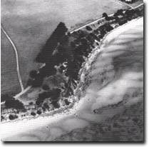 Cliffs in Baxter Formation, Red Bluff. |
Access: | Jetty Lane. | |
Ownership: | Crown Land. | |
Geology/Geomorphology: | Red Bluff is a 15 metre to 20 metre high coastal cliff south of Lang Lang Beach. It has developed on an outcrop of Baxter Formation ferruginous sandstones and clays that show strong mottling and discoloration. The cliff terminates at a ridge of higher terrain that trends south-east from the Bass Highway, this ridge being a topographic expression of the movement of the Wellington Fault (Jenkin, 1962). McMickan (1977) suggested that this structure be referred to as the Wellington Monocline as the movement in the Tertiary beds here is monoclinal warping rather than fault displacement. To the south of Red Bluff, the cliff becomes obscured by slump deposits and the accumulation of scree and beaches has produced a more graded slope profile. | |
Significance: | State. Red bluff provides a major exposure of Baxter Formation and this is the best coastal example of this formation in Westernport Bay. It is an important locality for the study of the stratigraphy and structure of these materials. The site is also a very useful teaching and reference site to illustrate the nature of cliff and bluff development in Westernport Bay. | |
Management: | Class 1. No artificial structures should be built at the cliff foot and crest or on the cliff face. No buildings, drains or other works should be permitted in the area of the site. A small car parking area could be provided north of Red Bluff and a sign-posted walkway provided to the beach. This is needed to stop pedestrian traffic degrading the exposures on the steeper cliff faces. | |
References: | Jenkin, J.J. , 1962. The geology and hydrology of the Western Port area. Dept. of Mines, Vict Underground Water Investigation Rept. No. 5. McMickan (1977). | |
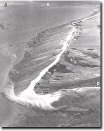 The multiple recurving spits that comprise Stockyard point. Also shown are Lang Lang delta (A), tidal watershed (B), Red bluff (C), part of Pioneer Bay (D). |

© State of Victoria (Agriculture Victoria) 1996 - .

This work, Victorian Resources Online, is licensed under a Creative Commons Attribution 4.0 licence. You are free to re-use the work under that licence, on the condition that you credit the State of Victoria (Agriculture Victoria) as author, indicate if changes were made and comply with the other licence terms.
The licence does not apply to ‘branding’ or some ‘images or photographs’ that may be owned by third parties. We ask you to seek prior approval to use images using the VRO feedback form. Access to higher quality images can also be provided on request.
This page was last updated on .