
101. Athlone - Lang Lang River Knickpoint
|
This information has been developed from one or more of these publications:
|
| Location: | Nyora - 866651. Fifteen hundred metres upstream from the Heath Hill road bridge. | 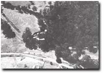 Knickpoint (arrowed) of Lang Lang River at Athlone. |
Access: | Lyons Road. | |
Ownership: | Crown Land (Public Land Water Frontage Reserve). | |
Geomorphology: | The site marks the limit of headward erosion of the Lang Lang River following rejuvenation subsequent to drainage and diversion works downstream. The knickpoint in the channel is formed in a firm sand strata that is being incised by the stream to develop groups of small potholes. Coalescence of these allows the knickpoint to retreat upstream to develop groups of small potholes. Overlying the firm sand material is a thin layer of coarse sand and grit and above this a bed of silt and sand over one metre thick containing many logs and other woody plant fragments. | |
Significance: | State. The site is of major importance in illustrating the rate and mechanism of retreat of the erosion head of the Lang Lang River. The steep banks display an important stratigraphic section of phases of late Quaternary sedimentation in the Lang Lang valley. | |
Management: | Class 2. Private unplanned and unco-ordinated erosion control works should not be permitted, as dumping of rock and other material will obscure the geologically important sections in the stream channel and banks. Consultation should be made with geomorphologists familiar with the nature of channel and bank erosion rates before any reclamation works are undertaken at the site. | |
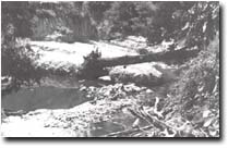 Knickpoint of Lang Lang River at Athlone. |


© State of Victoria (Agriculture Victoria) 1996 - .

This work, Victorian Resources Online, is licensed under a Creative Commons Attribution 4.0 licence. You are free to re-use the work under that licence, on the condition that you credit the State of Victoria (Agriculture Victoria) as author, indicate if changes were made and comply with the other licence terms.
The licence does not apply to ‘branding’ or some ‘images or photographs’ that may be owned by third parties. We ask you to seek prior approval to use images using the VRO feedback form. Access to higher quality images can also be provided on request.
This page was last updated on .